as of 4/09 there was no info (in english, anyways) about how to climb santa maria without a guide. there may be better resources online now.
volcan santa maria:
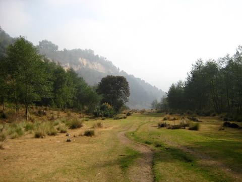
driving into Xela from the ciudad takes you by a perfect conical volcano with steep sides. why not hike up it?
the standard route is as follows:
first, take a taxi to the trail. every taxi person knows where to leave you. its 20-30 minutes by taxi from xela. as of 4/09 i was getting quotes from 40-100 Q for the ride from parque centrale, so choose what feels right. get dropped off at wide rocky wash at end of road. walk up for a half hour, or more, following good trails and ignoring offshoots to the side, until you reach open grassy braided trails continuing up.
|
|
at this point, there may be a few options of which trail to take as you head upwards, but stay on the left side. you are starting to look for a critical turn on the left.
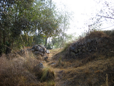
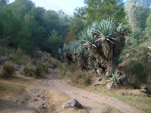
soon after these grassy areas the trail necks down into narrower trail and you get to that left turn you need to take to ascend. currently (4/09), the trail is marked with a few bits of string and a few hack marks in a tree a few yards up the trail. (see photo). it is just after a section of stone wall (see pic) on the left. it is a few yards up from the beginning of a big yucca-type stand of foliage (see photo). this yucca-type stand is probably the best landmark.
|
|
|
take this trail, choosing the well-traveled option if there are any splits, for another half hour or so, and get to a big sign at an open area and a pass.

|
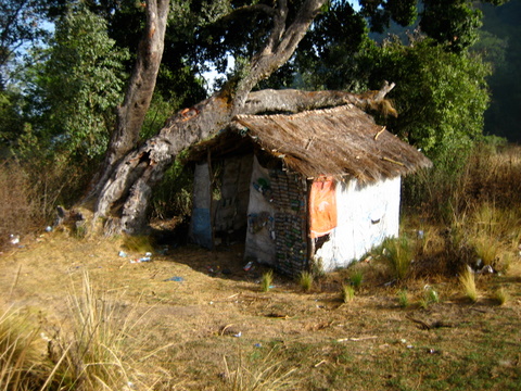
a trail breaks off right here (past trash can, and after a minute past a shack on the right.
|
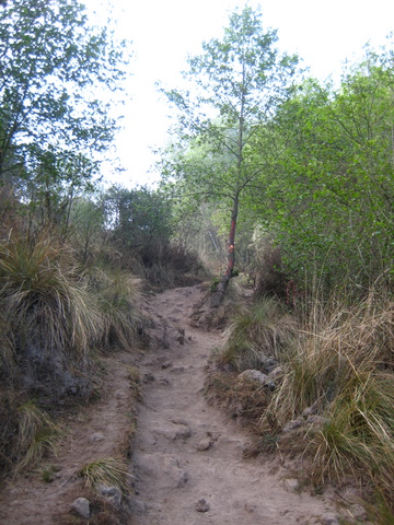
after this there are no more turns. follow obvious highway trail with deep dust and lots of pounded pickets that used to hold stair wood (probably long since burned) to the top. something like an hour and some from the turn to the summit, give or take *a lot* depending on your pace. there are a few offshoot trails, but none of them are remotely tempting. it’s a highway. if at any time on any part of the trail (here or below) you doubt youre on trail, youre probably not on the trail. its huge and well-beaten the whole way, with the possible exception of a few spots in the grassy area mentioned below.
at the top, enjoy the view (better in the morning before the mists rise), and consider walking a hundred yards down the backside (to the rounded sub-summit) where you get a better view of explosive eruptions every hour or so (im told theyre that frequent, but you might ask) that put a lot of ash into the air.
if you miss that first critical turnoff, you will eventually reach a high grassy pass where a grassy possible road cuts in. there is a small hut on the left here, with a big number '2' painted on it.
incidentally, not knowing how to get up the thing when i went, i hiked to this pass, and then took the first decent-looking trail up and left (a minute or two past the shack). this trail (or actually a network of braided human and possibly animal trails) started out fine (ie, moves quickly, although it is never anything as beaten out as the main highway), climbing alongside a radish farm for 20', then a winding trail network through the woods for a while (hopping a few makeshift barricades for no obvious reason in the middle of thick woods), then a sketchy semi-bushwhack trail for a while, and finally the trail disappeared completely necessitating a lot of offtrail mussing about on very steep grass and alpine foliage. all told, it was an excellent adventure, featuring almost none of the dust of the real trail, plus no people, no trash (past the radish farm), etc. however, its definitely adventurous, requires clothes you can get dirty in, a sense of humor, a taste for spiderwebs, a good flashlight/headlamp, and probably some trespassing. it was much more direct than the main trail and i made excellent time, despite a few backtracks and a decent amount of routefinding. basically, you just keep following which ever trail looks passable and goes up. there are no switchbacks, to speak of, which is why it goes quickly.
folks all say that the trail is dangerous, you will die without a guide, etc. however, its straightforward, findable even at night if you have a flashlight, and you wont get lost on the mountain. if you go on a busy day i doubt you will find any ladrones, as it gets regular foot traffic. i saw a few brave women make it to the top in sandals with smooth soles, and occasionally even 2" heels, but i woudl recommend the shoes with the best traction, as the trail is deep and dusty and you will probably end up on your tail-end a few times descending in flip-flops. of course, that wouldnt be the end of the world.
---
el baul.
the big tree-covered hill-mountain that seems to keep an eye on xela. this one too has a reputation as a horrible dangerous place. however, every sunday the place is covered with families grilling with their kids, and afternoons see a constant flow of families and their chilluns taking laps on the amazing concrete slides on the top. definitely dont walk up this thing without taking a few laps on the slides. sit on cardboard (its already up there) to protect your pants, or sit on a plastic bottle, squashed flat, for warp-speed.
anyways, to get up there you have two major options. first, you can take the road (by vehicle, or walking, either way, its a long long way. probably a couple hours walking in each direction, give or take a little). the upside of this is beautiful views of the hills around xela, of la muela, and a scenic route with no dust. the road wraps around the formation to keep the grade pretty flat. to find it, just walk up as if to find the trail (instructions below), but keep going past the turnoff and hug the road to stay as close to el baul as possible. eventually, youll get there. or ask a local.
for a more efficient ascent, take the trail. as if you were walking from parque centrale or parque bolivar, walk straight towards el baul. you can actually pick out a weakness in the trees angling up and right.this is the trail. when you cant walk any further towards the baul without trespassing/jumping fences then take a left on that last road. then take your first right, back towards the left side of el baul. walk up steep road for about a mile, avoiding small roads off right that are obvious dead-ends to residences or churches, past many tiendas, until the road opens up with a big grassy triangle on the left. about a hundred yards (estimated) past this you will take a dirt road angling hard up and right (it almost doubles back on itself, from the direction you were walking in before). as of 4/09 there is a black painted "baul" sign with arrow confirming the road, and of course the locals will know.
this dirt road passes a few houses, and ends and becomes trail in a couple hundred yards. from there, continue up on steep hardpacked dirt until you hit the road, cross it, adn continue up on trail. this takes 20-40 minutes walking, depending. it crosses teh road about halfway up. again, estimating from memory. the trail is less scenic, as you only have views of dusty trees, or of xela (which between the city air and the neblina, you wont see much a lot of the time). however, its quick, fun, etc. there are a few small animal trails and drainages that criss-cross the trail, but none of them will distract you. the routefinding is a cinch.
---
la muela
"the tooth" or "the molar" is a spiky outcropping with a very cool vibe. unlike santa maria or el baul, you are likely to have it to yourself, and its a pretty neat formation, and not all that much walking. be warned: there is great controversy among the locals about which summit is la muela, so take directions given at the roadside with a grain of salt (if you're trying to make it to *this* 'la muela').
i didnt get around to typing this up until now (10/09) so my memory is getting a little dim. however, i did take some notes. i recommend this hike/walk as probably the must-do one of the three, for its combined scenery and ease and proximity to Xela proper- close enough to go on an afternoon with no big plan-making. it features a solitary feel, and you can walk through fields of flowers in season. if my directions are off, just wing it. you'll see something neat up there- i promise.
first, ask a local where la muela is, so you know roughly where you're heading. from parque bolivar, walk along the main road towards parque centrale. turn left on calle 5a. walk up for a ways, and pass a big church on your right which has a big open area with a great view of xela for the way down (although be prepared to share it with some romantic teenagers if you go at night). continue up the road past the church until you hit a big road with heavy traffic coming in from the right, and diagonaling up and left. if you didnt nail the prior approach, you shoudl be able to find this big road.
take this up for five or ten minutes. youll see a big conifer looming up ahead, where the road bends left. that;s where you're heading. youll get to a big gas station on your left, the big tree is in front of you on the right side of the road (ascending). take the little road that shoots up and right there. pass a tienda on the right, and then wind your way up a road with very little traffic save a few bikes and the occasional van packed full of commuters. after a little while walking up this road, youll get to a sign for some hot springs (im told these are quite nice), and a road that leads to the springs on the right (a hard turn, almost doubling back and steeply uphill). ignore this offshoot (or hit it on the way down?) and keep going on your road, around a wide bend to the left as it hugs a drainage in the hills, and then keep a sharp eye out for a dirt trail shooting up off the road to the right.
take this little braided dirt path straight up. there are a few options, but just take the ones that head straight up. soon you will pop out near some short conifers at the edge of a field. to access what i believe are the 'candelas' volcanos, you could walk straight along the right side of this field, go up and over the pass you see in the distance, and continue on trail, but i never got around to that.
to get to la muela, walk along the right side of this field for a hundred yards, then cross left (on paths through and between fields of flowers, in season), until you get to a road. this is actually hte same road you got off of ten minutes ago onto the little dirt path, but its more fun to take the trail. on teh way down you could stay on the road if you wanted to catch a van on the way down, or wanted a different view.
continue up this road, which winds past flower fields then forest on the right, and other pastoral views on the left, and keep an eye out right. after a while you will get to a spot where it gets less steep, near some structures and a farm, and a broken looking path heads off at a sharp right turn. take this turn, which is memorable for about a quarter mile of steep walking up a broken semi-abandoned road with deep gutters, old paving stones, and a neat feel. you will reach a soccer field- seemingly in the middle of nowhere- after a while. from here, you can see la muela towering above you.
i crossed the soccer field, and headed up from the upper left side (as facing la muela). a trail weaves up, passes a little shack on the left, and scrambles up dirt and gravel trail through rubble and volcanic rock until you make a decision- go left around the buttress, or right?
left around the buttress gains a beautiful view of the la muela summits, and for the adventurous climber- a sketchy 4th/low 5th class scramble to the pointiest summit of the bunch (although i cant remember if it was the highest). this is not recommended unless you know what you're doing- its a hell of a lot harder to come down than go up, and no-one is going to come up and get you anytime soon if you blow it.
for a gentler outing, bear right at the buttress, up trail to a saddle between more accessible muela summits. there is a big shrine up here, and some nice spots to have lunch or dinner while you take in the sunset over Xela. for adventurers with a little more time on their hands, there is an endless amount of volcanic scrambling and beautiful terrain further back- if you want to get out of the usual drinking and camping spots and find something with less trash and a similar view. trash aside, this is a beautiful and solitary walk. i did see some climbing hardware so perhaps the locals are getting out here once in a while, but as far as i can tell its just not getting traveled all that much.
last updated 10/09. drop me a line with corrections or additions by going to the contact page.