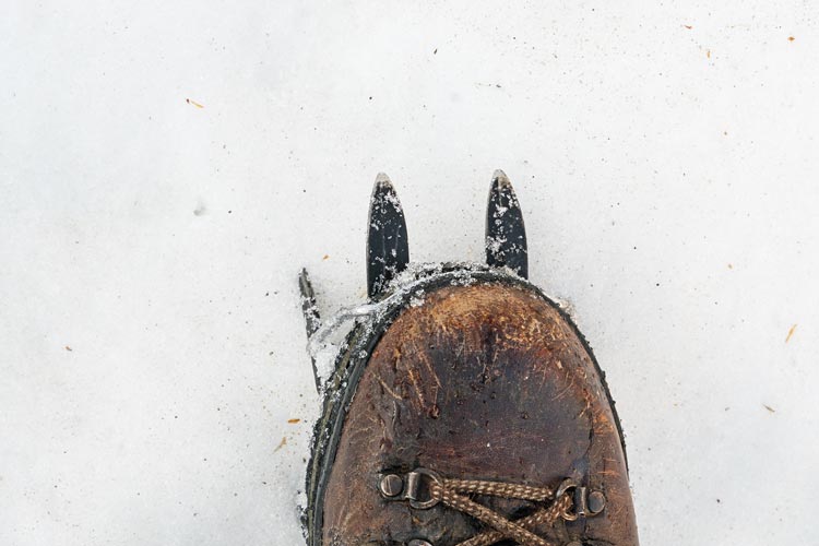
In preparation for some bigger upcoming trips this summer I planned something for the weekend - originally I was going to go long on Sunday out to an adjacent but higher peak from an earlier Sierra Challenge, but the forecast changed to include chance of afternoon thunderstorms so I scaled back a bit and decided on 2 new red dots out of South Lake that someone had added to Peakbagger. This would give me an opportunity to test out my old heavy duty boots and steel crampons among other things.
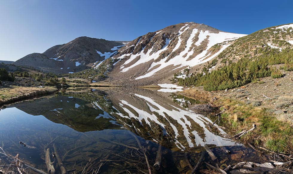
2025-06-08 I got up early and fortified myself with coffee and chocolate milk. The sun was lighting up the Sierra as I drove up to S Lake. Fortunately this time of year arriving early on a Sunday morning means plenty of parking. I put on my hefty boots and loaded 2 ice axes onto my pack and headed up the pipeline trail. Water was coming down the pipeline and the long ice axe was catching on trees in an annoying fashion. The big boots weren't great on the metal pipeline, but they were ok. I went past where the water was going into the pipeline at a split, after that it was dry. I was going to divert water into it at the end, but there were some missing sections of pipe near the top and the gate was locked closed. Heading up the trail my feet felt a little slow - the swing weight of big boots is definitely a factor, but it wasn't too bad. I powered up to the first lake (Brown Lake) and took some pics of the nice reflection. There was some frost on the ground before this, but a few mosquitoes in the still air here. I left the trail shortly after the lake and headed SE towards the drainage where I put on my steel clip-on crampons - definitely an advantage of big solid boots. The snow was mostly pretty good although I did have a few postholing moments. I went to the left side of the snowfield where it was still in the shade to decrease this.
| |
|---|
 |
|---|
tromp tromp tromp I went up the snowfield. It wasn't very steep, so I just kept using my ski poles instead of pulling out an ice axe. I followed the snow up the slope until it started getting rotten near the top. After wallowing a bit and having difficulty getting my feet out (one foot would plunge in and then the other would pack the snow on top of it making it hard to extract) I got off onto the talus and took off my crampons. This is where the boots were definitely not helping since I had minimal articulation with my ankle joint. I clomped up the talus a bit like a skier tottering around in ski boots. Fortunately I had poles to help with balance. It didn't look like I had far to go to the summit, but in reality it was almost 1000 feet more to gain. The views from Peak 12682 were pretty good and I stopped for a snack. Then I had to drop down to the notch before heading up to the next peak.
The descent was a lot more technical than I thought it would be, especially in big boots. At least they edged pretty well. I found a way down a bit of a chimney and steep ramp and then traversed a bit below the notch and another gendarme before starting up. Originally I was only going to do 2 bumps, but I was starting to get more ambitious, and rather than do a very steep traverse I figured I'd at least head up to another peakon the ridge. I had already been up Peak 13112 back in 2014 when I was just exploring around in the snow. This time I came up the ridge - slowly, since by now the air was feeling pretty thin and oxygen was in short supply. I slowly made my way up for another break and to enjoy the view.
 |
|---|
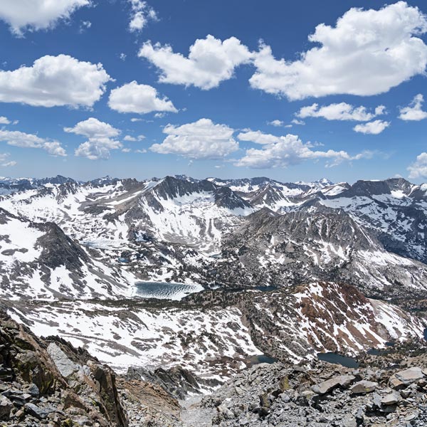
I had already done more than planned, but wwCHd? (what would Chris Henry do?) I mean Vagabond was just "right there" and Cloudripper "just" beyond it. The weather looked like it was holding, although there were clouds building. I hoped to avoid going over Vagabond but my attempts to side-hill around it were met by steep cliffs - or at least blanker and steeper than I wanted to climb with my boots. So I went up and over the west end of it and then dropped down across the flat and across a short snow patch to start up the rocks towards Cloudripper. I was definitely feeling the altitude and boots by now, but just kept moving up onto the summit ridge and then to the summit. It took a bit of looking around before I found the register. The hinge on the ammo can was busted and the books inside were damp. I spread them out to dry a bit while perusing the pages - lots and lots of entries by people I know in here including a few by me. I found a blank place to sign with the pretty busted pencil stub, ate another snack, took a lot of pics, and then tried to seal it back up with enough rocks to hold the lid in place.
 |
|---|
I felt pretty clunky going down, but there was some decent snow which made for a very fast descent until it didn't. The last 20 feet I was just sinking through the rotten mashed potatoes onto whatever sort of rocks were under the snow. I waded through never quite knowing how far my foot would sink and then back across the flat saddle and up towards Vagabond. It was frustrating having to go back up - but it does make for another peak and really didn't take that long. For the descent I headed towards the snow and after a few rotten steps it was decent for a while before collapsing again near the bottom. I got some snowmelt here to augment my water supply (I was long out of chocolate coffee) and then headed down to the saddle below. There was another red dot to turn green - one that wasn't there last time I was here or I would have tagged it. It wasn't really obvious what the high point was, so I visited a few likely bumps, and watched a hawk doing aerial manouvers. It would head straight up and then coast to a halt and drop down and below the horizon before popping up to do it again. I took some pics, but it was pretty far away and nearly silhouetted against the sky. Maybe it was an eagle.
 |
|---|
Now all I had to do was head down to the trail and follow it back. But first some more rock and snow of various quality before I hit the trail. It was definitely easier to move at a more reasonable pace once I hit the trail, but my feet were sort of hurting by now. You don't so much break in boots like this, but break in your feet, and they didn't like the process. Fortunately there was enough of a breeze down by Green Lake that the mosquitoes were mostly not an issue. I lost the trail in the snow but it was pretty obvious what general direction to go and I found it soon after. There was one stream crossing with a log that only made it halfway across so I had to make a pole-assisted jump onto a submerged rock and then to the far bank. The boots might be heavy, but they are mostly waterproof. I finished the last of my snacks by Brown Lake and then just kept on moving down the trail and then the pipeline back to the parking lot. I had used the top of my pack to contain the ice axe ends a bit better so at least that wasn't catching on the trees. Back at the parking lot I quickly swapped out my footwear to avoid mosquitoes and relieve my feet and then headed back home. Sadly the boots weren't particularly comfortable, although they did stay mostly warm and dry. There was some delamination at the leather-rubber interface that let in a bit of moisture and needs a bit of work. Hopefully I can glue it back together. This was my first trip above 13000 feet this year and also the first with such heavy footwear in a while. I wasn't feeling vary fresh.
strava page for Cloudripper hike (2025-6-8)