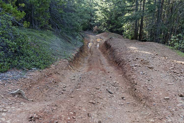
it will be secure once I finish blowing it up anyway
We applied for a heap of river permits, which I generally just consider giving money to Booze Allen to help them lobby to further tighten their screws on our public land access. (I'll give you a free guess if I am a fan of Wreck.gov or not). We did one paddle on the Owens where I used an SUP and Iris paddled my old Alpacka packraft. She did well, but this wouldn't be sufficient preparation for a bigger trip. In any case, that means that we needed to get better and more comfortable at packrafting, especially Iris, as I have actually done a fair amount over the years. So we (mostly I) decided that having a double would get us up and running faster. I think you can be much more capable in whitewater in a single, but at least for a bit it would work better for a double for us, so, ensue some fiscal bleeding.
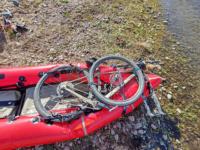
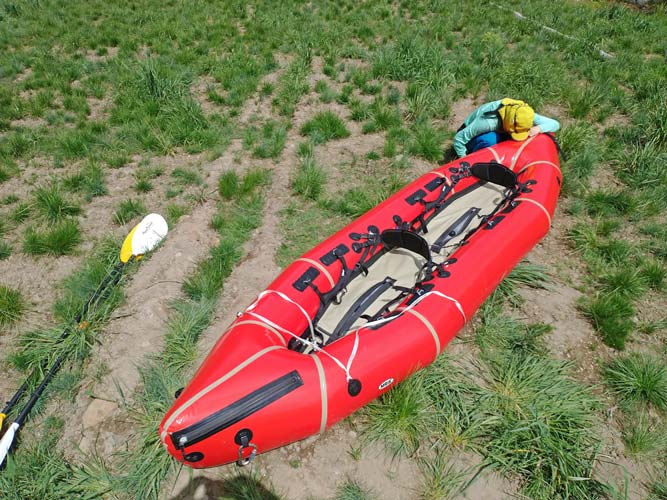
I ended up ordering another paddle and a MRS Viking Evo 2, which is a self bailing double packraft outfitted with a Tizip for internal storage and thighstraps. Iris got a drysuit and a pfd. I tested out the double with a solo bike shuttled trip on the Owens R. I biked to the 5 Bridges Road bridge and inflated the boat and strapped the bike on the front. This worked remarkably well with the front thigh straps locking in the rear wheel and ski straps to lock the front of the bike on the front of the raft. This left me plenty of room to paddle from the back seat. I paddled down to Warm Springs rd - some 19 miles. There were very few actual waves - just one tiny spot, but the current does try to push the raft into the willows on either side of the river as it meanders around the valley. I saw a lot of birds on this trip - from ducks to an owl. The fire department was training swiftwater rescue stuff at the takeout. Then I loaded the boat into my backpack and biked home. success.
I started working on a review of the MRS Viking EVO2 packraft
| |
|---|
2026-4-2 We headed up from Bishop late on a Thursday and stopped so I could jog/hike up a bump just N of June Lake and then made our way to Nevada where we slept at the takeout for the E Fork of the Carson - something we were considering paddling later on in the trip. When I went to plug in the fridge the next day I realized I didn't bring the cord for it. We tried to find one at Walmart (they had it online but not in the store, and we could only order it sent to our home in 3 weeks, not a store on the way in a few days). Oh well. I guess we just had a heavy cooler. Fortunately I had frozen a number of items before I left and in fact between that and keeping the unit out of the sun and sticking the fridge or at least water bottles out to cool at night and judicious eating we managed to not lose any of our perishables over the trip. The next day we continued on back through N California to OR and a campground by a reservoir on the Rogue River (Joseph H Stewart State Recreation Area). Wonder of wonder it had showers. Chris Kerth met up with us that night.
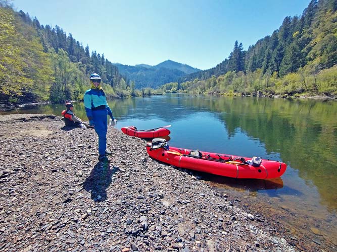
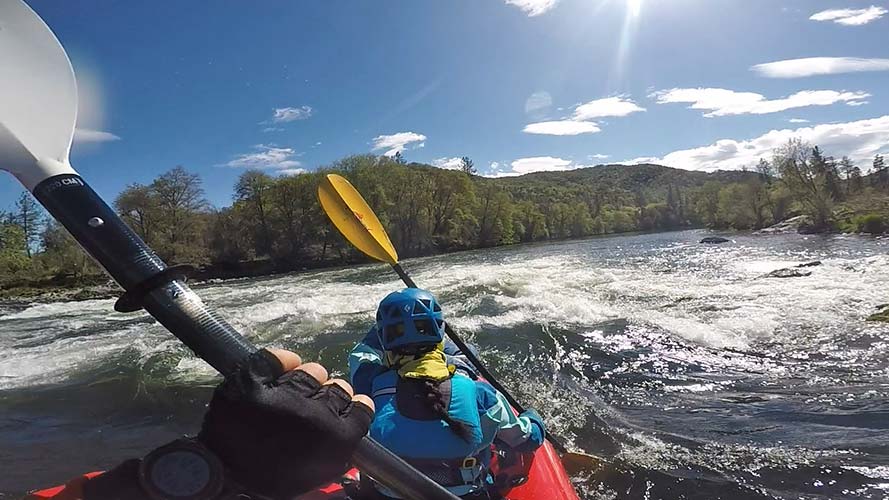
link to Strava page for Peak 7964. 04-02-20262026-4-4 We got up pretty early as we planned a 25 mile paddle. I was confused and thought we were staying here again that night so I left the tent up with bedding in it. OOPS, I was wrong, so we packed up hastily and loaded it into the Element. Then we drove to our planned takeout and left Chris' vehicle there and drove back to the put in below Lost Creek Lake at the MacGregor Park Boat Ramp. We saw a number of turkeys on the drive and one bald eagle. We saw and heard quite a few turkeys on this trip, including a number of males displaying their tailfeathers and strutting about. Then we paddled down the river. It was mostly class I with a few pretty mellow class II sections - a good warmup, but we could have handled a bit rougher whitewater. Still, it was nice to not get traumatized right off the bat, and we got to do a lot of paddling as we covered about 25 miles to the Touvelle State Recreation site. Iris did paddle a section including one rapid in the back of the raft. She did a good job, but burned a lot of energy keeping the raft on track and decided it was a better job for my man arms.
By the time we finished paddling, packed the rafts up, drove back to the start, and then drove to the camp at Indian Mary Park for the night it was pretty much getting dark. This campground also had a shower, although I'd have made it warmer if I could have. We had a fire that night.
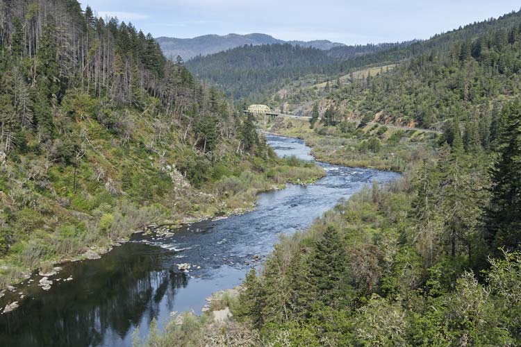
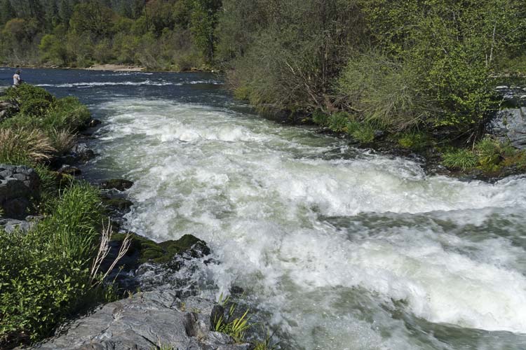
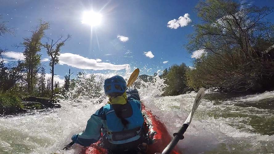
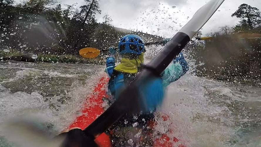
link to Strava page for Rogue River Packrafting MacGregor Park to Touvelle. 04-04-20262026-4-5 Today we planned to paddle from Hog Creek to Grave creek passing the town of Galice - a pretty popular section. First we drove the Element to the takeout and then drove up to the summit of Mount Peavine, a drive up p1K with a tower at the top and then to a LoJ nothing peak before stopping at the Hellgate Canyon overlook on the way to the put in. There were a few damaged pictures of Hellgate Canyon during a massive flood in 1964, I think the maximum measured during that flood was ~152,000 cfs (cubic feet/sec) at Grants Pass and ~290,000 cfs at Agness - very impressive. It was more like 1550 cfs when we were there, dropping to 1400 by the 7th (in 2025 it was ~5600 to 4900 cfs during these days which is probably more normal). While we were inflating our boats a cataraft showed up. They launched just before us and we had to hold back through the first rapid to not run into them, then we passed them in the flat water. Hellgate Canyon was pretty mellow even though it was narrow because it was so deep. This section had some fairly flat water and some pretty exciting but mostly short rapids with areas to recover after them if things didn't go well. This is a lot less scary than long continuous rapids where an early swim could be a long swim. It featured up to class II+ (some say class III, but probably not at the lowish water level we got). We had a few waves completely swamp the raft, and it did take a bit for the water to drain out - maybe 30 seconds? The raft is pretty sluggish when full of water, but it is also very stable. We practiced flipping and getting back into the boat in one calm section. This also cooled us down as it was getting hot in the dry suits in the sun. We saw a golden eagle, osprey, lots of great blue herons and mergansers and mallards and occasionally pretty big fish jumping. The biggest rapid along this stretch was Argo - still probably only class II+. This run was about 15 miles. At the takeout there was a class III rapid right below the takeout and online it said you could run it and then take out after and hike back to the takout. This rapid went on both sides on an island. We paddled to the island to scout it and decided to run the section on the left of the island and then walk the raft back up the island. This skipped the final drop of the rapid and probably kept it under class III. We ran this - probably a step up from anything else we ran that day as it was more continuous. Carrying the raft back up was a bit of a pain, but we made it and paddled back to the takout. Then loaded up and drove up the road above the river to a Rainie Falls overlook. It did look impressive way down below. Then we went back to the put in. There we loaded into Chris' vehicle and drove up to Peak 3520 - another P1K, but we didn't have the 4wd ability to drive all the way up. That took more time than expected and it was pretty late by the time we got back to camp - still we had time for showers and dinner by the fire.
 |
|---|
 |
|---|
2026-4-6 We ran the Hog Creek to Grave Creek section again. We tried to go through more of the bigger waves and holes and also switched up who was in various rafts - Iris paddled the single through a few rapids. When we took a break after one of the rapids I paddled the single back up and tried to surf the wave at the bottom. That meant I flipped and swam. AT the bottom we ran the start of the gold creek rapid we ran the day before and then scouted the final drop of that rapid (Grave Creek Falls). It was another step up - probably class III, but also just a single drop with a large recovery area after it. We ran this successfully and then took out on river left and packed up the boats and hiked out. The crux was dodging poison oak on the way up to the trail - and then there was more on the trail but it was easier to avoid. Then we headed back to the put in and Chris headed home. Iris and I headed east across I-5 and up into the hills towards another P1K. The road took us past a homestead with some dogs with death wishes - they pretty much just stood in front of the tires and barked - often hiding below the visibility line of the hood. It took minutes to get past them, someone should probably just run over their owners. We stopped for the night at a wood cutting area that also seemed to be a shooting area, although nobody was there at the time.
 |
|---|
2026-4-7 After breakfast we drove farther up the hill towards the summit, but soon were stopped by a rougher section - we might have been able to make it past, but figured it was better not to risk it. We did a 6 point turn and backtracked to a decent parking spot and then headed back up on foot taking more direct but definitely rougher 4wd roads. The number of cans and bottles along the side suggested that drinking and driving these roads was a popular pastime. We continued on up on a mix of 4wd and better dirt roads. Some were on the map, others were not. We consulted the satellite images to make our best guess of the easiest way to proceed. There was an antenna tower by a saddle and then another almost at the summit. The actual 4438 ft high summit of Elk Mountain - another p1K - was a nice boulder that was clearly higher. Conveniently we had reception there as well as some decent views.
 |
|---|
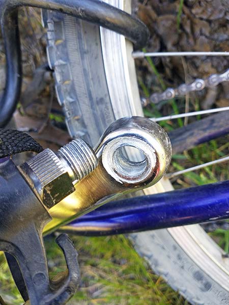
The descent went more quickly and soon we were bumping back down the dirt road. We took a different route to avoid the suicidal dogs and then headed towards our next paddle with a detour to get gas at a cheaper place. Then we dropped off the bike at Riverside Park next to the Rogue River and drove to the put in at a recreation area in Gold Bar. Iris suggested I scout out the Ti'lomikh Falls right above our put in to see if we wanted to paddle that (it looked scary from what I could see) and when I came back I saw the park closed at 8 and was a little worried about how long it would take to paddle and then bike back up. Once we got on the river we tried to keep a steady pace aided by the usually moving right along current and hampered by the upstream wind. According to my watch which when set to SUP tells me the pace of each mile we were usually doing 10-15 minute miles. I am guessing more than half the distance was due to the current rather than our paddling. There were a few decent rapids along this stretch, mostly near the beginning, but nothing as impressive as the last rapid we paddled the day before. We cruised down the river past parks and homes and took out at the park where we carried the boat up to a covered area. There we quickly got off our drysuits and set stuff out to dry on the fence. I changed into shorts and a dayglo long sleeved t to improve my visibility and then headed off back to get the Element. I probably biked a few miles before I remembered to turn on my tracker so I don't know how long the ride was - somewhere in the 16-18 mile range? ChatGPT said it would be 12 miles. I tried to keep up a good pace, as I was still worried about getting out of the park before 8. About half way through the ride my left pedal felt weird, and by the time I stopped to check it out it was loose in the crankarm. I tried to crank the pedal straps onto my foot harder, but realized it was probably terminal as the steep of the pedal reamed out the soft aluminum of the crank. Fortunately I had pedal straps so I could lift and push with my right foot and push the left pedal into the crank. I am guessing that I didn't tighten the pedal enough when I put it on - although I did turn it hand tight and then another turn with a wrench. I made it to the Element around 7:45 and quickly put the bike on the roof and then headed back to get Iris as it got dark.
Meanwhile Iris had been having her own adventures which included getting attacked by mosquitos and having a homeless woman offer her some KFC chicken. The road to where she was in the park was closed off for construction so I had to park and walk over. We were able to take everything in one load and I ate a piece of chicken. Then we did a very cursory rinse in the bathroom and headed to an In-N-Out for burgers before heading off to find a place to sleep. Our first try was blocked (the area is only open during the day evidently), but after a bit longer drive than desired our next location was nice - another clearcut at a saddle in the mountains where people shot things. There was a chance of rain so we tetrised everything into the Element and went to sleep.
link to Strava page for Elk Mountain. 04-07-20262026-4-8 We slept in a bit and then headed off walking up a 4wd/ORV trail (road?). At some point this just traversed below the ridge so we left the trail and bushwhacked our way up to the summit of Peak 3411. Not as easy walking as the road, but not too bad and there were some nice flowers including some kind of little orchids. At the summit there were signs of prospecting and associated trash, and also another ORV trail. We followed that down to where it met the other road and then back to the Element. Then we drove back down to the Rogue River where we stopped to look at Ti'lomikh Falls from river left (it didn't look as bad, but still pretty rough) and then up to Dillon Falls - also known as Nugget Falls. We were able to get a good look at this and although it looked rough, the bad part was short and if you flipped you would get flushed out quickly. Then we drove a few miles upstream and unloaded the paddle gear. Then I drove back to Dillon Falls and prepared to bike back up. I went to wet my hood for cooling and the rock on the side of the canal there gave way and I went into the water. At least it was warm. By the time I got back to Iris I was nearly dry and I could just pull my pedal out of the hole in the crank. Still, with the pedal fastened securely to my foot it was possible to keep the pedals turning without just using only one leg.
 |
|---|
 |
|---|
 |
|---|
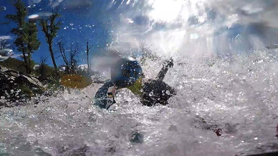
This paddle started out with flatwater and a few smaller rapids. Then there was a water diversion weir which created a strong flow with an abrupt eddy line at the bottom which was a bit exciting. Then we went into Dillon Falls. There were quite a few people around and below this area as we approached it (as opposed to nobody when I dropped off the Element). We hit it pretty much the way we planned to, but a sideways wave caught us at the bottom and over we went. Fortunately as predicted we got flushed out. I stayed with the raft and ended up getting onto it upside down while Iris ended up floating down the river feet first until she ended up sitting on a rock. We pulled over and took the raft out. Then I scouted just walking the raft back above the weir to try again. Meanwhile a fisherman told Iris this was the lowest water level he had ever seen for this time of the year and it was so low that the fish were having trouble getting up Rainie Falls. The portage looked pretty easy to do, so we carried the raft back up above the weir and then paddled down again. This time we managed to stay upright - much more satisfying. We contemplated running it again, but decided to quit while we were ahead. We still had to pack up and drive back to pick up the bike. Then we drove closer to the highway to decide what to do next. It looked like weather was coming to this part of the world and our options involved heading south and then east or heading east and then south. Heading east first looked like we would get another half day or so without too much rain so we got gas and hot water to make ramen and then headed up over the mountains towards Klamath Falls. Unfortunately this drive was steep and twisty and in a driving rainstorm. When it wasn't raining there were deer on the road. Still, the rain had mostly stopped by the time we got to a nice campground on the Klamath River. We left the raft outside on a picnic table but put everything else in the Element while we slept. We did notice a sign requesting us to rat out the area if we saw "Any signs or other information that are negative about either past or living Americans or that fail to emphasize the beauty, grandeur, and abundance of landscapes and other natural features". I wonder how that works at a place like Alcatraz where mentioning people were in jail could be considered negative.
 |
|---|
 |
|---|
 |
|---|
2026-4-9 It had been a late night so we slept in a bit and then scoped out the Klamath River. There were a number of pretty scary sounding rapids downstream like Caldera, a long class IV, so we didn't want to run those. They had relatively recently (2024) taken out a dam and powerplant a bit upstream so the beta on this section was a bit confused as the river was still coming back into equilibrium. Still, it looked like at least one class III rapid if we put in by the old powerplant and then ran down from there taking out before the class IV stuff. We scouted downstream but there wasn't a great takeout on this side of the river and the bike shuttle was making me nervous, so we decided to just run it from the old JC Boyle powerplant (now gone) down to the campground. We drove up there and scouted a few sections - we could put in a little higher, but it looked sort of continuous with some potential consequences of an early swim. I left Iris and the boating gear near where the powerplant used to be and then drove back to the CG in the rain and biked back up mostly not in the rain. The steep uphill near the beginning was a pain but the rest wasn't too bad. Then we prepared to paddle and put in.
 |
|---|
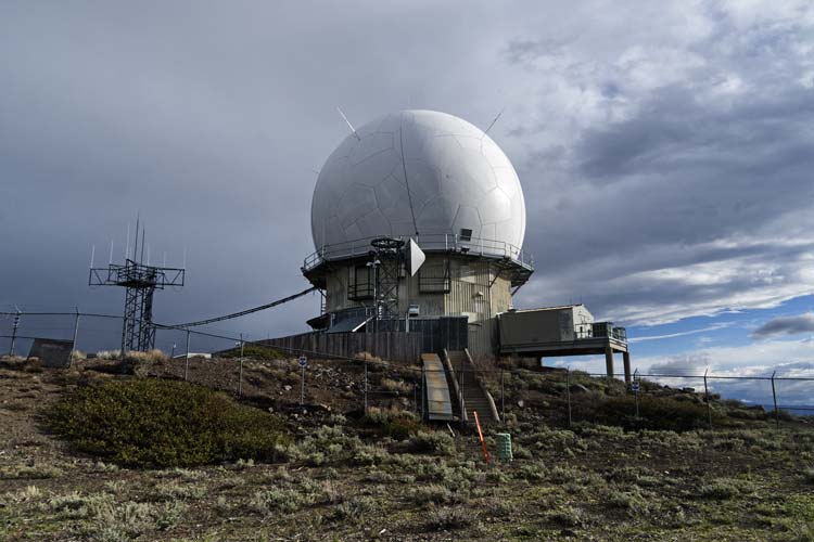
Almost immediately things got exciting with waves and holes coming fast and furious. We mostly executed our scouted plan, but did run over a few surprise rocks and holes and the raft got completely swamped at least once. That got us down to Spring Island - another possible put in location. We stopped to add some more air to the now very well tempered raft and catch our breaths. There was one more maybe Class III rapid starting here - with a somewhat hard to see mostly submerged boulder creating a large hole. We successfully dodged that, but hit a few more things and once again completely swamped. There was a little break at the bottom of this rapid and we collected ourselves again and then proceeded downriver. The rapids were not as exciting after as we paddled down some flatwater and a few class II (+?) rapids and soon we could see the Element. We took out and thought about doing another run, but figured we had a long way to go. We had originally planned to run the E Fork of the Carson on the way back down, but the forecast for there was for snow. We decided that was probably not a good idea. There was a drive up P2k - Hamaker Mountain, so we decided to do that on the way, but first the last chance to get cheaper Oregon gas before heading back into California. Then we drove a long winding road up 6598 foot Hamaker Mountain. There was an FAA radar installation on the summit, but we were able to walk up to a high point along the fence and called that good enough. Then Google Maps sent us down a dirt road on the south side of the mountain. This gradually got worse and worse until we decided it was a bad idea and did a 5 point turn and started back up the not great road. The Element did a great job and soon we were back on the pavement and heading back down. We drove along the border for a while and then down to Tulelake (home of the Honkers) where Iris had seen great reviews for a Mexican place (Señor Tequila) . It was in fact very tasty and we quite enjoyed it before continuing on south to camp just north of Eagle Lake.
 |
|---|
 |
|---|
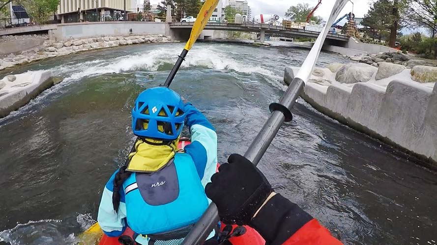
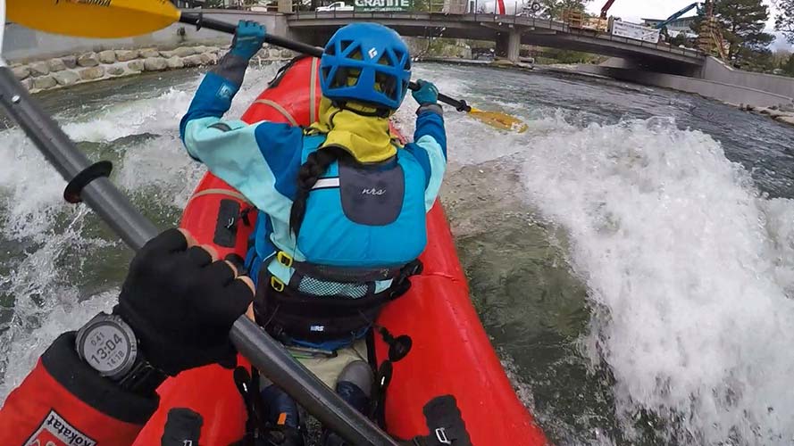
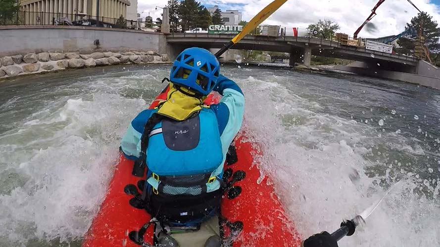
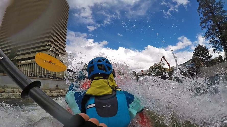
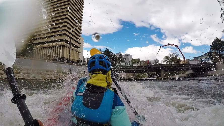
2026-4-10 Today we drove south to Reno. There we went to the whitewater park on the Truckee River at Wingfield Park. They were doing construction work on the bridge, so we couldn't drive the way we wanted to and ended up parking and walking closer to scope things out. It turns out we needed to drive the wrong way on a one lane - one way road to get there (they had people directing traffic so we wouldn't meet someone coming the other direction). Then we inflated the boat and did a number of runs down through the park, sometimes all the way down, sometimes we took out and walked back up on the island to just run the first few drops again. We almost flipped when a fisherman cast right over us causing a distraction - fortunately we got clear of the line before it dropped down to our level. We also played around with surfing in a few of the smaller holes. With a strong downriver lean we managed not to flip even when we turned sideways (the usual outcome when I tried to surf a hole in a single). While I was leaning and bracing downstream Iris was able to paddle forward to get us out of the hole, nice. With the boat nearly empty (just a few things in a bag in the bow and in the seats) it was quite light. I found it easiest to just carry it myself on my head, although gusty winds were a bit of a problem. All in all, a fun little outing. They definitely should build a little whitewater play park somewhere on the Owens River near Bishop. Then we went to the Patagonia store and the Gear Hut where I splurged on a mid-drive e-bike. After loading that on the roof we headed to Lowe's to get parts for river waste containment systems and some white roof coating. Then to Kristine's place just off of 395 where we put some stuff into a shipping container to get it out of the rain and went to bed.
 |
|---|
 |
|---|
 |
|---|
 |
|---|
 |
|---|
2026-4-11 We slept in a bit and then hung out with Kristine checking out her place and animals. Despite getting completely burned in a wildfire a few years back it is still a pretty nice place and slowly recovering. Then we headed south back into CA with a stop just before Conway Summit to walk up to a peak (Sinnamon, or maybe Conway overlook). The weather was looking a bit threatening but mostly held off until we were back in the vehicle. Then we got a bit of rain and snow as we continued S to Mammoth and then home.
link to Strava page for Sinnamon or maybe Conway view peak. 04-11-2026