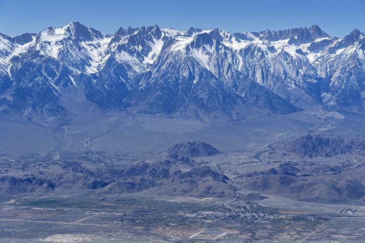
I had a 3 more days I needed peaks and it seemed that the snow had receded enough that the DPS peaks in the Southern Inyo Mountains were a possibility. I still needed to climb New York Butte and Pleasant Point so they were the main targets. Originally I planned to do Pleasant Point from Cerro Gordo and NY Butte from down in the Owens Valley via Long John Canyon , but I decided to try to get both of them from Cerro Gordo by using my mountain bike.
2026-03-13 I packed up and drove down in the afternoon/evening heading past Keeler and turning off towards Talc Peak. The road in was good enough and I parked where there was a spur and headed up the hill via headlamp. There were some outcrops of metamorphosed limestone which made for some interesting scrambling but mostly it was a straightforward hike up the hill past a false summit to the actual 5706 ft summit. I found a register there and signed in and then headed back down. Back at the truck I crawled in and went to bed and researched the peaks for the next few days. This is where I decided to try to get both of them from Cerro Gordo.
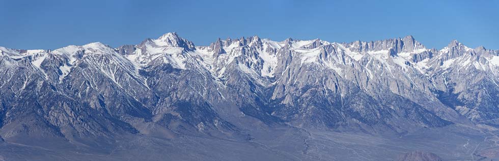
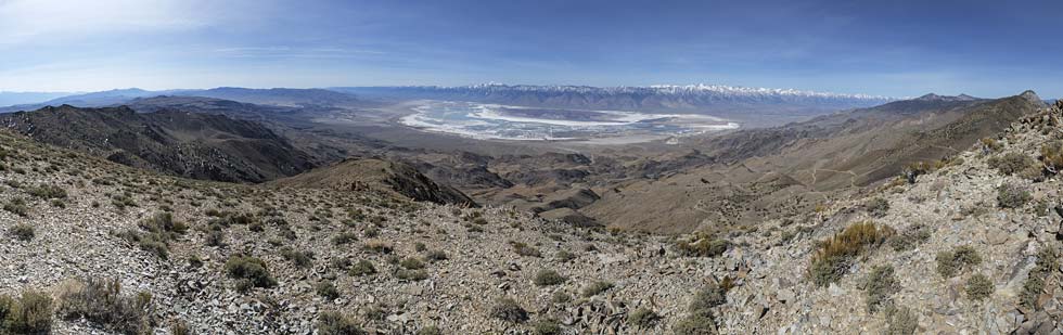
link to my Strava page for Talc Peak. 03-13-20262026-03-14. I got up in the dark and quickly got out driving back towards Keeler and then up the road to Cerro Gordo. The road was in pretty good shape, but long and steep with occasional washboarded sections or larger rocks to dodge. The truck made it up with no problems, but most of the way I was in first or second gear. As I got to Cerro Gordo there were lots of no trespassing signs and open 9-5 and so on. It was a long time before 9, so I stopped at the parking area and was looking at the map to decide if I should/could drive through the townsite and back onto public land when a guy came up. He said I couldn't get much farther with my 2wd truck and should park here and that I would probably get stopped by snow before I got to the salt tram by bike. I parked and got my gear together for a long day. Before heading off riding up the road.
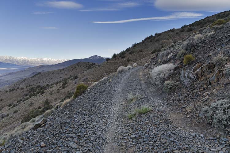
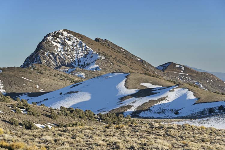
After a little bit of steep uphill through Cerro Gordo I took the road to the Swansea Grade. This mostly traversed along the edge of the slope around 8800 feet and it looked like my truck could have made it to a level turnaround spot on public land. I continued bumping along the rocky and somewhat off camber (sloping downhill) roadway generally level and then descending a bit to a nice turnoff to a camping area on a ridge. There things headed downhill steeply and I rode the brakes and was glad to have warm gloves as I dropped down another 700 feet or so to about 7460 feet. Then it started uphill. Soon it was too steep and loose for me to ride so I started walking my bike up. Up and up and up as it turned out all the way to about 9000 feet where I wandered about for a bit to ensure I was at least close to my first point of the day - The Cerro Gordo Wilderness Study Area (WSA) highpoint. A completely pointless point with no prominence whatsoever. It was close to the road though and a red dot I could turn green. Then I got back on the bicycle and was able to mostly ride up to a saddle and then down the other side where the road completely disappeared under the snow. This was more of an east facing slope but must be a place that the snow drifts. I was able to ride on top of the snow a little bit but soon was walking along pushing my bike. This was sort of like a Magness adventure race. At least the snow was solid enough that neither my feet or the bike wheels sunk in too far. I also refilled the water bottles I had been drinking from with snow. Past the east facing slope the snow was gone and I rode up the road until I was below the next peak. I left my bike and pack and walked up to the 9479 ft summit of Mexican Spring Peak. I also found a mylar balloon here. I left it in the road with a rock on top of it for pickup on the return.
| |
|---|
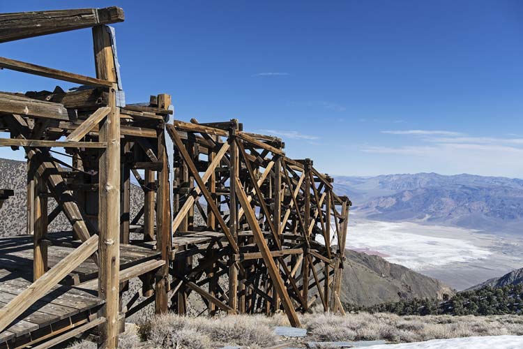
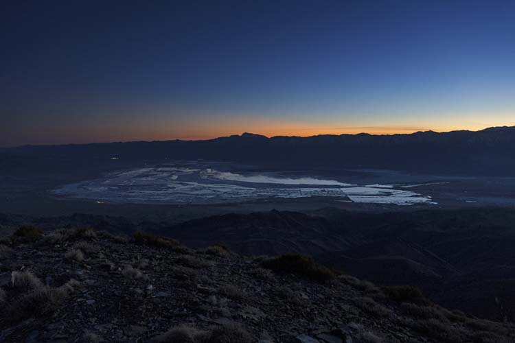
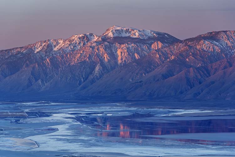
I continued on the road, mostly able to ride. There was a spur heading closer to the next bump and I took that until it got too steep to ride. Then I walked the short way to Peak 9444 - a Peakbagger only point with only 214 ft of prominence. Once I got back to the road things tended to go downhill for a while. This meant I made much better time, but also meant I would have to head uphill on the return. Soon I could see where the salt tram went up and over the Inyos from Saline Valley to the Owens Valley as well as an adjacent cabin. I continued downhill to this point passing a few smaller snowpatches. I got off the bike and explored and took pics of the tram and cabin and left a water bottle there. I continued downhill to a saddle and then back up the other side. Mostly the grade was rideable, but there were sections that were easier to walk. Then there was another east facing slope and valley that was full of snow. More walking and pushing. Eventually I got through to snow to a rocky ridge that was mostly easier to ride than pushing along the snowy road. Now I could see where we had cut over the Inyos on the 2025 Lonesome Miner Trail hike. That area was covered by snow now but it looked like most of the way there was on a SW facing slope that was melted out. I rode down along that slope and parked my bike and left my biking stuff there along with some more water.
 |
|---|
 |
|---|
 |
|---|
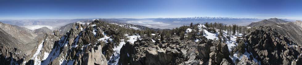
I was almost entirely on snow for a bit. I discovered that I was less likely to post-hole if I stayed on the road since the sagebrush under the snow created booby traps. Fortunately the snow didn't last that long - just long enough that I didn't want to deal with it and the bicycle and also after a relatively short bit the road headed steeply uphill. I slogged up to near the Burgess Mine and then shortly left the road to head up to Inyo Peak 10151 with 271 feet of prominence. It did have some nice views though. Then I dropped back down to near the end of the road and started up a bit of a trail that looked like it was heading up NY Butte. Sometimes this trail was quite obvious, other times it disappeared. I lost it in a snowpatch (that was annoyingly post-holy) around 10200 ft. There I just traversed up the slope until I saw some cairns that I mostly followed up to the 10668 ft summit of New York Butte - a DPS peak that Iris did back in 2018. I was about 7 hours into my day. NY Butte was my goal, but I really wanted to continue on to tag another 10,000 ft peak about 2 miles farther. I went back and forth about if this was a good idea (of course it wasn't a good idea, but more how bad of a bad idea would it be). I figured it would add at a minimum 2 more hours to my day, and more likely 3 or 4. That means I would possibly finish after midnight with a lot of biking and at least one more peak in the dark. I was still considering continuing on, but the plentiful snow on the N side of NY Butte helped me decide to head back instead. That would mean leaving a peak in between lots of peaks I have done, but also only be tired instead of extra really tired, plus the N facing snow might have been a bit sketchy or very slow going.
 |
|---|
 |
|---|
 |
|---|
I made much better time back down to the road and then was able to just follow it back to the bicycle instead of detouring to the peak. The snow was getting a little softer in the afternoon but I was still able to mostly stay on top of it. I drank a bunch of water when I got back to the bike and then headed up the road. It was sort of the opposite of the ride in except where I had to walk the steeper uphill sections and ride my brakes on the steeper downhills. The lower angle sections were rideable and made for decent speed either way. I generally did a better job of avoiding the snow on the return, but I did crash a few times on steeper downhill sections. Mostly when the front tire stopped due to loose soil or snow. Fortunately these were low speed crashes, but I still somersaulted onto one shoulder or the other into the sagebrush or ground a few times. Other than the snowy section I managed to make pretty good time back to the saddle. Things slowed down a lot heading up to the salt tram where I picked up my water and beyond up to where the road leveled out. I picked up the balloon I had left and then took a detour up over a peak instead of the longer snowy section. It had more up, but less snow. I'm not sure which was quicker but if the snow was as soft as the last bit I had been on maybe the more up/less snow option was better. On the other hand the snow was in the shade now, so maybe it was more solid. This next bit of slightly downhill road was probably the nicest riding of the day - smooth and slightly downhill, why couldn't it all be like this? I parked a little after the WSA HP as the sun set behind the Sierra and started up the hill. I had to dodge some trees and bushes and a few steep rocky sections but mostly it was easy enough travel up to the ridge. On the left side there was snow, and too far to the right it got steep. I followed the ridge near the edge of the snow up to the top - Pleasant Point at 9690 feet and another DPS peak that Iris did back in 2018 (I think they drove a 4wd vehicle up to Cerro Gordo and then along my bike route). I didn't need my headlamp to get up to the peak, but I did need it to read the summit register. The pen wasn't working so I donated a pencil (memo to self - replace spare summit pencil in my pack). I flipped through the register a bit and tried to take pics (but it was dark). Sadly there were a number of peaks between here and Cerro Gordo that I wouldn't be tagging tonight. Fortunately they had under 300 feet of prominence so I didn't feel compelled to visit them. There was a chilly wind blowing so soon I headed back down.
 |
|---|
 |
|---|
Back at the bike I stashed my camera in my pack and geared up for some steep downhill riding. It was steeper than I expected, and more treacherous. There was often a deep gully in the middle of the road so I had to pick a side to ride on, and if I was on the wrong side it dropped off into the gully or was quite rocky. I crashed a few times when my front tire plowed down into the gully in the middle of the road. Most of the time I was able to stick a foot down and gracelessly dismount but once I went totally over the handlebars and did a mini-superman before rolling on a shoulder. Ouch - and a lot of dust everywhere. There was a lot of downhill made more painful by the fact I knew I would have to just regain the elevation lost. Eventually I passed 7460 ft again and started up. Soon it was too steep for me to ride and I was once-again pushing my bike uphill in the dark - it really was a bit like an adventure race. There was less wind here and soon I was taking off my hood and gloves and pulling up my sleeves to keep from overheating. The next 800 feet of up took a while with only a few short breaks where I was able to ride. Then I was able to bump along the rocky road the last mile or so back to Cerro Gordo. I tried to scope out the road to the turnaround and it seemed passable to my truck. When I got back my watch was at 29.87 miles and I was slightly tempted to ride the extra .13 miles to bring it up to an even 30. I was tired enough that I didn't bother. Instead I took off my pack and helmet and strapped my bike to the rack and then drove up and out of Cerro Gordo to public land. There I spent a tiny amount of time to slightly level my truck and then crawled into the back to drink a protein shake and eat some rice and beans and go to sleep. I was tired. It might have been Pi day, but the only pie I got was humble pie.
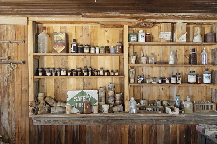
link to my Strava page for NY Butte, Pleasant Point ++. 03-14-20262026-03-15 Beware the Ides of March - at least if you are a dictator. In any case I woke up well before Cerro Gordo opened at 9 so I ate some yogurt and rice and hiked straight up the hill to the road up a peak there. This road traversed around to the north side and switchbacked up to the summit from there. I followed this road on up to the summit of Peak 9200. This peak has only 240 feet of prominence, but it was right there and had nice views as well as a bunch of antenna that I think belong to the FAA. I dropped more directly down to the road and then followed it back to directly above my truck where I dropped down again. Then I slowly drove back to Cerro Gordo to park. I headed up to the "general store" where I checked in with the guy there and looked at some of the displays (all sorts of cool stuff they had found in the area). I also talked about my trip the day before and listened to a bit of the tourist talk that he was giving to some other people that were there. He said I was welcome to hike up the road to the peaks on that side.
 |
|---|
After talking a bit more and looking at more stuff I headed up the road. There was a chill wind out of the north and I was glad to have an extra layer on. It was a little too warm the few places where I was out of the wind though. I switchbacked up to the saddle between the peaks up here and then headed up 9120 ft Buena Vista first. This peak was on the Owens Lake side and did indeed have a Buena Vista. It also had a bunch of antenna towers and some buildings. I took some pics and then sat out of the wind in the lee of one of the buildings. Then I headed back to the saddle and up Cerro Gordo Peak. The road didn't go to the top, but it was pretty easy cross country travel up to the 9188 ft summit with 948 feet of prominence. Evidently this peak had been on the DPS list but was delisted for some reason. The register was in a canning jar inside of a tackle box. It was also quite soggy inside. I opened it up and spread out the 2 register books to dry. There was also some sort of paper that was extra soggy - I think a Cerro Gordo Peak sign. I decided that was trashed and took it down. I was mostly out of the wind here and relaxed for a while to give the registers a chance to mostly dry. Then I closed everything back up carefully and headed down. I stopped at the library building and went in - lots of books about ghost towns and mining and so on plus old bottles and other artifacts. Then back to the center of town to look at the assay building and a few other buildings before heading back to the truck.
 |
|---|
 |
|---|
I switched to a t-shirt and loaded up the truck and then started the long slow drive down. Nothing was particularly hard, but I had to keep the speed low enough that the washboards wouldn't start bouncing me. That meant either riding the brakes or first or second gear depending on how steep it was. Probably 1.5 gear would have been right for most of it, but that wasn't an option. Eventually I made it back to pavement and then drove home. The temperature was quite high for mid-march. Probably 15 degrees or more above average for the last 30 years and even more compared to the average before that.
link to my Strava page for Peak 9200. 03-15-2026