Tom Grundy's Death Valley Jan 2025 Page
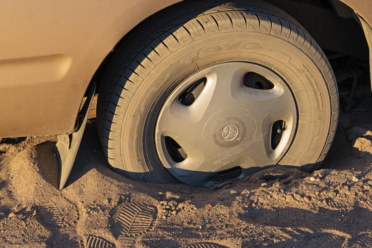
2025-01-16 We finished packing up to head out to Death Valley for the long weekend and headed out. Almost immediately we had a problem. The truck stalled and when I tried to restart it the starter barely budged and then smoke started coming out from under the hood - not good. I coasted to the edge of the road and then after a quick look to make sure there were not fires I tried to push the car back to the edge of my street (I was under one block from home). I wasn't able to push the truck up the berm of the road while wearing mock crocs. I ran back for more substantial footwear and then pushed the car back and to the edge of my street (with the help of a guy who pulled over and helped push). I grabbed a headlamp and volt meter and started poking under the hood. Working hypothesis - the battery was jolted out of place (I got rear ended into another vehicle earlier that week - a long story to be told eventually?). The movement of the battery loosened the ground connection to the starting motor causing the current to flow through the much too thin ground wire - burning the insulation causing the smoke. I grabbed some more tools and a wire and disconnected and reconnected the main ground connection plus replaced the ground to frame wire. The truck started right up and we were back on our way. We gassed up along the way and then continued on through the night to where we met up with Bob. As I pulled off the dirt road the back tires sunk into the soft sand. I was stuck, and the truck was far from level. We leveled up the pads inside the truck a bit and went to sleep. It was one of those days.
stuck truck
 |
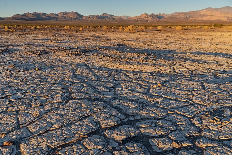
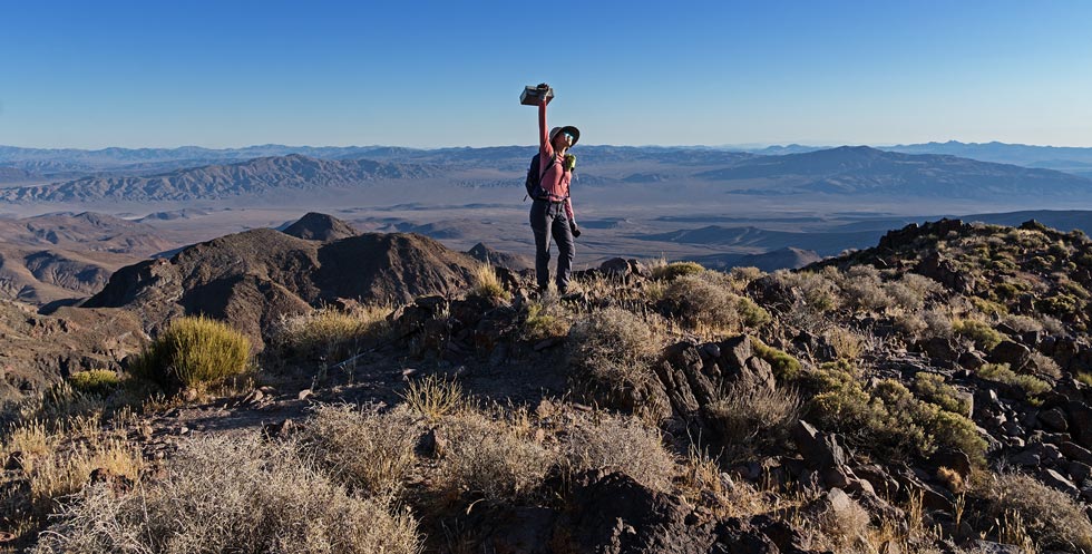
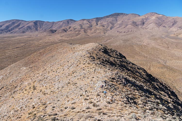
2025-01-17 We got up with the sun and greeted Bob. He was able to easily pull the truck out with a tow strap and Jeep and we headed up the Warm Springs Road. We stopped on the side of the road and headed up a peak to the south. This was Peak 3074 - a pretty straightforward tromp up the slope and ridge with expansive views of Death Valley.
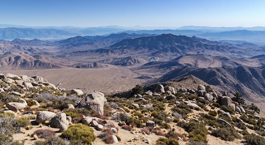
southern Death Valley view
 |
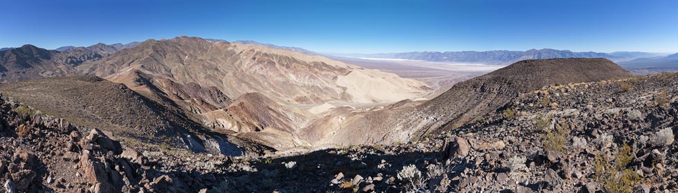
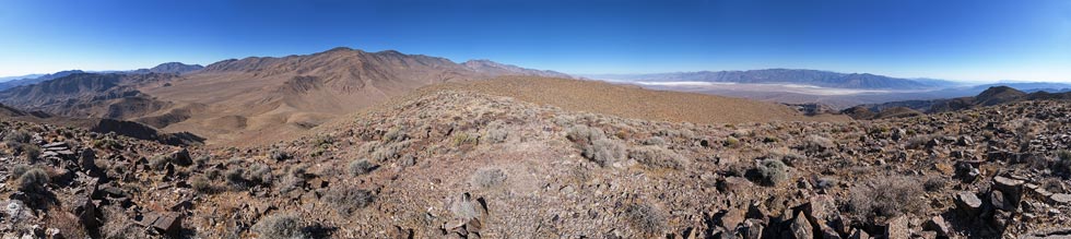
We drove a bit more up the road and then headed north up the slope to Peak 3090. We were able to follow old mine roads part of the way up, but then it was cross country. Then we headed to a lower east summit that was on Peakbagger. Then we generally retraced our route back.
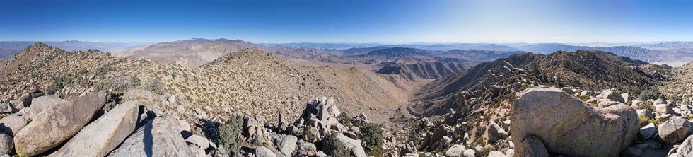
panorama from peak 3090
 |
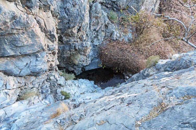
Another short trip up the road brought us to Warm Spring Campground - once a residence and mining (talc) area. The owner basically stole it from the native americans and held on to it by force. There were a number of springs in the area and some flowing water. I would later take advantage of a warm spring to rinse off after hiking. We poked around a few of the buildings and then headed off to the south up a peak. We started out up a wash and then transitioned to a ridge as we headed up the side of Peak 3910 - also known as antenna point (at one time there was at least one antenna up here, and some of the foundation still existed). It was still fairly early, so we headed down the ridge to the west and eventually at a saddle cut right and followed a drainage back to the vehicles. This had some interesting downclimbs and then a cliff near the bottom with a pool of water at the base. We were able to cut out and down on the skiers left side and ended up back at the most intact building. Back at camp we rinsed off on the slab and discovered mice had infiltrated the truck. Oh no. Things had been chewed and droppings were dropped. I was not happy - and I didn't have any traps with me. Iris was even more upset. That night we could hear them chewing. sigh.
looking down at the warm springs pool
 |
Strava page for Death Valley - Butte Valley Peaks. 01-17-2025
Bob's trip report for 1-17-2025
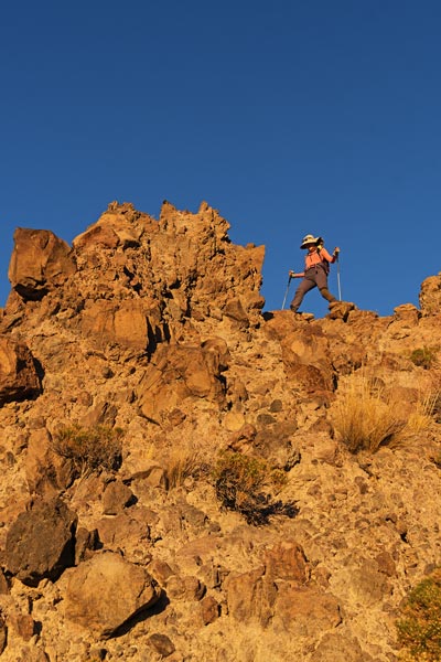
2025-01-18 We took the Jeep up the mostly pretty good, but long and rocky road up to Butte Valley. Iris and I were here to climb Manly and Needle - 2 DPS peaks. Bob had already climbed them, but he had some other peaks to climb and kindly dropped us off and picked us up as we made progress on the DPS list. It was chilly when Bob dropped us off on the N side of Manly, but we warmed up quickly as we hiked uphill. Bob drove farther up the road and then hiked up Peak 6551. At first the footing was pretty good and progress went well. Then things got sandier and we slowed down a bit. Nothing stopped us, but it is demoralizing and tiring to slide downhill when you step up. We made it up to the ridge and started following that. We had to dodge around some extra rocky gendarmes and cliffs. The going was slower than we expected. Finally we made it up to the "false summit" and made our way across the saddle and up to the summit blocks of Manly. These were indeed quite impressive blocks, but pretty easy to get up with a bit of momentum on a step across or scrambling. At 7196 ft this would be the highest peak of the weekend. We signed the register, texted Bob, and then started heading back down. The weather today was particularly nice - 50s, sunny, and a cool breeze. It was pleasant hiking and just a little chilly stopped in the sun. Downhill was more pleasant than uphill - especially in the sandy sections. We probably stuck to the ridge a little more - following a trail of old NPS boundary markers. The last slope downhill went nicely until we got below the sandy section and then it was much more work heading downhill. By now we could see the Jeep back at the road and we were soon back with Bob heading east towards Needle.
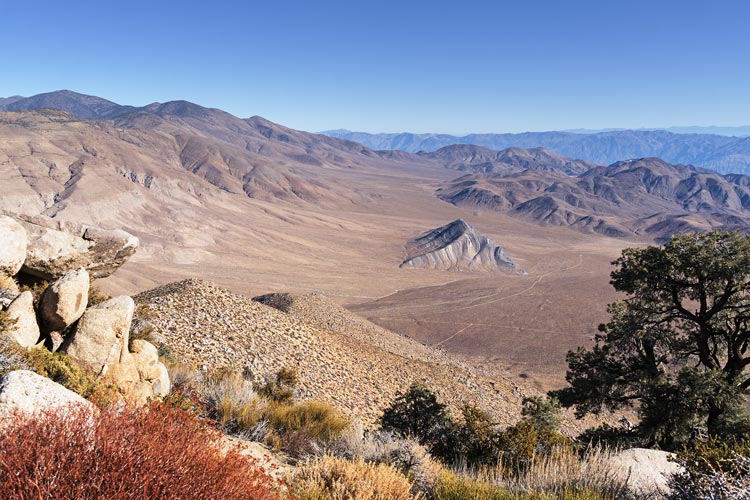
view down into Butte Valley with Striped Butte in center
 |
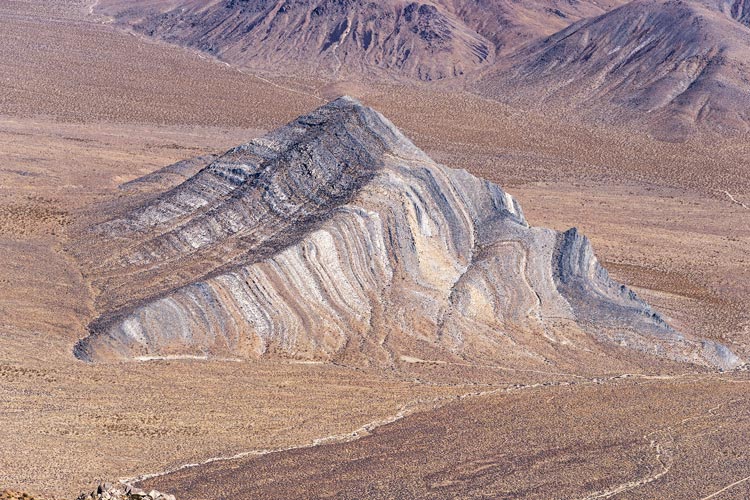
Striped Butte
 |
view over towards Needle (dark peak center right) from Manly
 |
360 panorama from Manly
 |
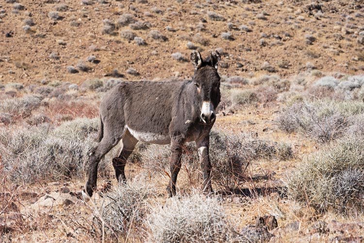
We detoured to check out a cabin (geology cabin?). This one was in pretty good shape and had quite a lot of supplies and other things in it. Then we headed down to the end of the road where there was an awful lot of burro poop and a few burros. Also another Jeep which turned out to have a guy who was searching the area for a bunker. He was unable to interest us in his search - we had peaks to climb. Iris and I headed off to the S to hook E towards Needle. Bob headed E to Peak 4117. We wrapped around the toe of a ridge and then up over a saddle on burro trails. Then we cut out of the drainage and cut across the ridge before dropping into the drainage that went up the E side of Needle Pk.
We followed the drainage uphill to the S. following burro or social trails as best we could. At the saddle we turned left and headed up the slope. It didn't take long before it got steep and rocky. We picked a path up through the cliff bands following a mix of various animal or peak bagger trails. It was not fast going and there was a lot of up to go. Eventually we made it up past the cliff bands and up the ridge to the E summit. Then we dropped down across the saddle and up the final slope to the 5804 ft summit. We stopped for pics and to sign the register and then headed back down. We were hoping to at least make it down through the cliffs before the sun set. We did get that far, and in fact made it most of the way back but we did need headlamps for the last bit. We loaded back into the Jeep and drove back to camp. By now it was cold and after a bunch of de-mousing in the truck I hiked up to the pool at the base of the cliff we skirted around the day before. It was in fact warm - maybe 75 degrees? Not bad in it, but not as warm as ideal, and a little rough getting out. At least it wasn't very windy. That night we had more mouse issues and not enough sleep.
Iris and the summit register on Needle Peak
 |
Iris descending Needle Peak
 |
Strava page for Manly and Needle, DVNP. 01-18-2025
Bob's trip report for 1-18-2025
2025-01-19 We headed back up the road towards Butte Valley and turned right and went to the end of the legal road (the road continued, but it was closed, and it was pretty faint. We followed the old road down into the next valley and then cut cross country up to the summit of Peak 4580. Then Iris and Bob headed back to the Jeep while I cut up to the summit of 5492 ft summit of Gold Hill, a P1k that they had already done back in 2018. As I was heading down the S side to continue on to Gold Hill S Peak I could see them approaching the summit. I tried to hurry down the slope and across the saddle and up to the summit, but they were getting a little chilly waiting for me near the 5320 ft summit. We used the camera level function to decide that a bump out to the SE was lower and didn't need a visit. Then we headed back to the saddle and then on down to where the Jeep was parked near the end of a 4wd road up to an old mine.
panorama from the summit of Gold Hill - Death Valley is on the right
Needle is on the horizon on the left with Manly center left and Telescope about the center
 |
Iris and Bob approach the summit of S Gold Hill
 |
We headed back towards the Warm Springs Road and parked on the side of the road and stopped to hike up another peak - 4206. This had a pretty steep slope and then a ridge up to a satisfactorily summity summit. I scoped the descent from Between Benchmark from here across the valley to the south. Then we headed up towards Butte Valley for one last hike.
Iris and Bob descending Peak 4206
 |
wild burro
 |
This might have been our last hike of the day, but it was far from our least. We started off up onto a ridge and then looped around to get up Peak 4997 with Iris leading the way dancing to her tunes, then we returned back south on the ridge before looping around and following the ridge top to Peak 5085 - not that close, but it was generally easy travel. There Iris and Bob headed back to the Jeep and I continued down across a saddle and up towards Between Benchmark. There were some steep bouldery sections that slowed me down a bit, but I tried to go fast so the others wouldn't have to wait for me. I made it up to the 5253 ft Between Benchmark (between Butte Valley and Warm Springs Valley). It looked like there was another possibly higher point on the other end of the summit ridge, so I went over there and it was in fact probably higher listed as 5265 ft (and had another summit register). Then I hurried back towards the Benchmark and looked for a place to drop off to the N.
Iris on the summit of 4997 Benchmark behind her and 5085 on the right
 |
view N from Between Benchmark
Gold Hill is just left of center with S Gold Hill closer and to Rt
4206 is harder to see center left about the middle top to bottom
 |
I found a likely ridge and headed down. Mostly this went pretty well, but it was steep and rocky so it took some planning and care. Still it felt like I was making decent time. It got pretty dark about the same time I hit a mostly sandy wash. This headed a bit too far to the east of where we planned to meet, but the easy travel in the wash was too good to leave. I managed to make it all the way to the road without using the headlamp although it was pretty much dark by the time I got there. I checked my gps and determined I was in fact too far east down the road so I started walking up the road. I got chilled in the cool air blowing down the road and stopped to put on another layer. Soon after that I saw some headlights coming down the road - they figured they could drive down to see if I was waiting somewhere else and drive back up if necessary, but instead they met me hiking up the road. We drove back to camp where I managed to catch a mouse in the back of the truck (I had an old t-shirt I used to protect my hand while I just grabbed it.) Sadly that wasn't the only one. I also rinsed off again in the warm spring. This time I used a water bottle to collect the warmer water flowing out of the spring to pour on me. Not ideal, but a lot better than some situations. There was another mouse filled evening, I saw one silhouetted against the window and another tickled my ear. They taunted us with seeming immunity although by now almost everything edible was stashed in a plastic crate or on top of the truck, I hates them .
Strava page for bumps plus Gold and Between, DVNP. 01-19-2025
Bob's trip report for 1-19-2025
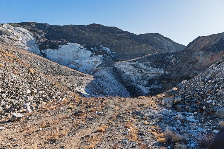
2025-01-20 This was our last day - so we had a shorter outing planned. We didn't know how far we could make it up the Jeep road - not as far as we were hoping. We got out and then got back in the Jeep to prepare out of the cold wind - a cold front had passed and the weather had changed. Did I mention there was a cold wind? Normally once hiking uphill I warm up and need to take a layer off. Today at some point I realized that wasn't going to happen and instead as we got higher and closer to the ridge I added a layer. We went up the old mine roads past some extensive old mining (talc?). The wind near the ridge was strong enough to disrupt straight line walking and I was worried that the ridge above the old pit mine would be hazardous. It turned out there was an old road/slope on the upwind side away from the ridge. Then we left the road for a short jaunt up to the 4501 ft summit of Galena Hill. I didn't see any galena though (lead sulfide - which has characteristic cubic crystals). I braved the wind a bit to take photos down over Death Valley and then we sheltered behind the ridge where it was surprisingly pleasant.
talc mine
 |
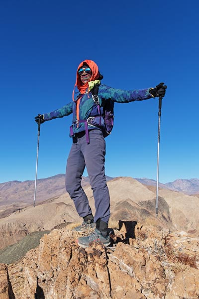
Iris in the wind on Galena Hill
 |
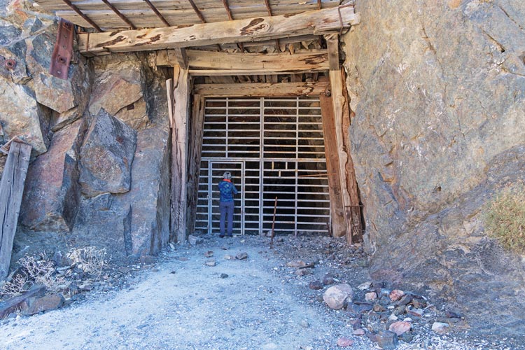
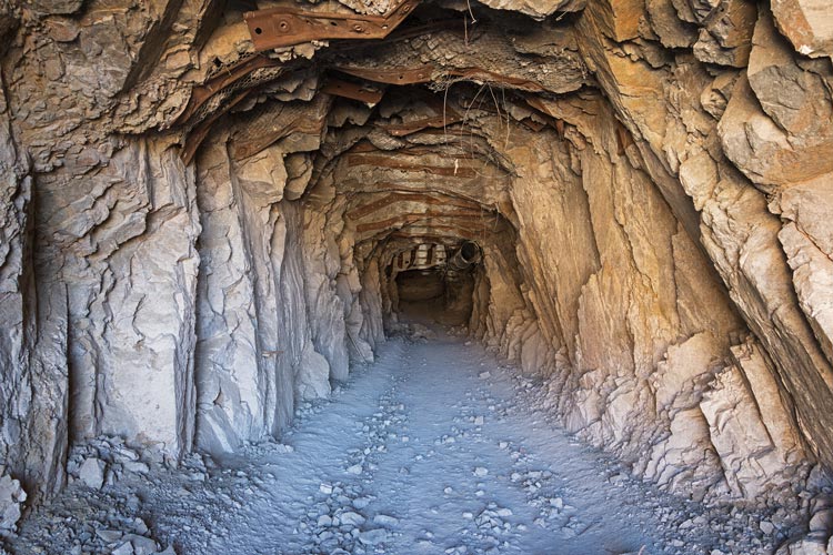
We headed back into the wind blast to head back. At least once we were off the ridge the wind was at our backs. We took the Jeep back to camp and Bob headed our for his long drive back home. I found a chunk of wire I used to fasten the battery in place more securely (it had worked itself loose on the bumpy drive here). We took some time to take a look at the talc mine near the camp. It featured an impressive tunnel (big enough for a truck) heading into the side of the canyon. I would have liked to explor, but there was a massive cage over the entrance suitable for Jurassic Park - that meant I probably could have slithered between the bars - but it would have taken some effort. Instead we headed down the road, soon passed by an Inyo Co Sherrif SUV heading up the canyon.
gated mine entrance - Iris for scale
 |
view into the talc mine
 |
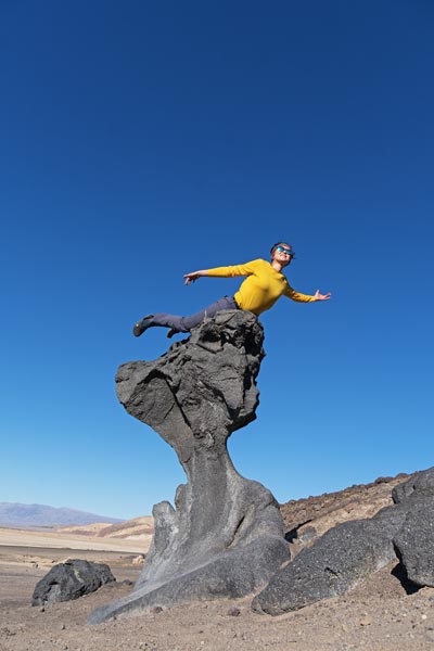
We stopped before we got to the pavement so I could hike up Cinder Hill, not much of a peak with a summit elevation of -75 ft, but it is sort of cool to be able to climb peaks below sea level, and there were some cool ventifacts on the summit ridge. Then we headed N past Badwater Basin with a stop at 2 more below sea level dots - Mars Hill at -194 ft and Mushroom Rock at -250. Somewhere along here the Sherrif passed us heading N - they were definitely driving faster than I do - especially on the rocky dirt road. After Mushroom Rock we headed back home. I was a little worried I'd need gas before the cheaper station at Ft Independence, but we made it. Back home we emptied out the truck and I set a mouse trap in the front and back of the truck. I checked a few hours later and had caught one in the front. I set it again but that was the only one I got (and I saw no more evidence of the evil rodents).
Iris posing on Mushroom Rock
 |
Strava page for last day of DVNP Peaks. 01-20-2025
Bob's trip report for 1-20-2025
No material on this page may be copied or used without permission.