Chris Kerth had plans for Glacier NP in July and asked if we wanted to join him. Unfortunately Iris had to work, but I was free, so I packed up and then drove up July 17-19. I started fairly late the 17th, and soon I lost decent radio and tried to play an audio book from my phone - it said the memory card was corrupted and there was nothing there. sigh. Later that night I copied stuff from it onto my laptop, reformatted it, and copied stuff back. I lost a fair bit of offline maps and other data, but at least I got my audio back and it seemed like the stuff I had downloaded for Montana was mostly still available.
The drive was mostly long and uneventful. I saw a few pronghorns and deer as well as the usual raptors. I did stop to go up a few bumps along the way. The first was a bust - I thought I could drive or walk up to some antennas, but it turned out there was a house up there too. The second ended up being on private property, but it was empty rangeland so I just went up anyway getting to the summit around sunset. I also saw an owl up there which was cool. I also jumped into Red Rock Reservoir.
7-20-2024, I was sleeping at the Glacier View Overlook (Roger's Glacier) and got up early. I was a little worried because Chris wasn't there until almost our planned departure time (it turns out he had a flat tire doing a peak the day before and had to change that). We started at about 6 am and headed off down the trail. Sadly we started out downhill for a while before turning west onto the Gunsight Pass Trail uphill to Gunsight Lake. We got water there and then headed up the Jackson Glacier Overlook Trail. We powered up that and then left it to head up the NE ridge of Jackson. We worked our way up the ridge following a use trail as the possibilities were reduced. We gained a lot of elevation passing the trail runners who had passed us earlier on the trail. Near the top we saw some clawed footprints in the snow - maybe young grizzlies or wolverine. The summit was a bit west along the ridge and we worked our way over to that. The views were pretty awesome even though there was a fair bit of haze from wildfire smoke. At 10,052 ft this was the first of the > 10,000 foot peaks in Glacier NP we would climb - there are 6 and Chris had already climbed one and hoped to finish the others on this trip.
On the return we took a quick dip in gunsight lake. Then a few miles from the trailhead there was a bit of rain - enough to get us to put on our raincoats and completely soak our legs and feet (mostly from pushing through the wet plants). The sun came back out and we were mostly dry before we made it back to the trailhead.
That evening we went up to Logan Pass. There was some more rain there, but it stopped in the evening. There was a flock of bighorn sheep that went through the parking lot before heading up a nearby hill for the night. I was a bit nervous about sleeping in the lot here, but it seems I wasn't the only one and we had no problems.
7-21-2024 Today we were planning on going up Reynolds Mountain and Dragons Tail, and maybe more if we felt extra fast and energetic. We started off on the Hidden Lake trail. This is a very popular trail and was almost a boardwalk for much of the way. It was closed beyond the Hidden Lake overlook because of bear activity, but we were turning off before that. Here I will add a few words on hiking in grizzly bear territory. We were both carrying bear spray (like a can of mace on steroids) as well as an air horn. If we were hiking on a busy trail like this we didn't do anything differently, but if we were alone we would yell out "hey bear" every hundred feet or so or whenever we were going over a hill or around a corner and couldn't see what was ahead. Also whenever we were reminded by bear scat on the trail. Supposedly there were no reported bear attacks of groups of over 3 people, but we were just 2. Also we we tried to increase the frequency of yelling when heading upwind or near a loud stream of if the wind was noisy. The goal was to alert the bears to our presence and allow them to get out of the way before we got to them. The thing to really avoid was surprising them and most importantly to not accidentally get between a mother and her cub or cubs.
| |
|---|
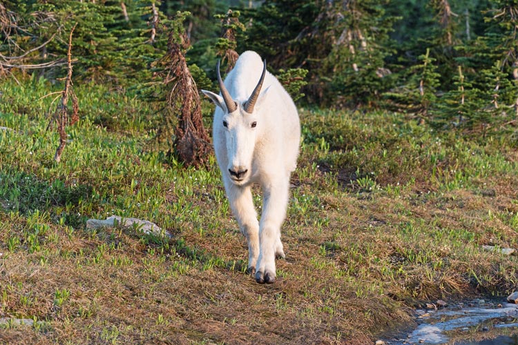
We left the trail and headed towards Reynolds. There was a mountain goat in front of us that kept walking ahead of us along a use trail, but stopping to forage so that we wanted to go faster. We eventually made an end run around it and continued on towards the peak. The trail was decent and we continued on up one of the many branching options up the peak. It looked very steep from below, but the nature of the rock (semi-horizontal sedimentary and metamorphic layers) lends itself to pretty easy scrambling and traversing as long as the rock doesn't fall down. We worked our way up a pretty obvious and well traveled route on the shady W side up to the summit. In fact there were others heading up and down as we went up. The views from the top were most satisfactory. Then we headed down trying to take advantage of scree descending where possible.
Next up we dropped down below some snow and then scrambled up along a long traversing bench on Dragons Tail. I did slip on some wet grass on the descent but didn't slide far. We were mostly following a use trail that was probably mostly used by mountain goats. Then we headed up a steep gully mostly staying to the right of the drainage scrambling up to the ridge top. From there it was a pretty mellow walk up to the summit. We enjoyed the views and then reversed our path back to the very crowded Hidden Lake trail and Logan Pass.
Next I drove west on going to the sun road. I ended up behind a dually pickup truck that might have been over the 8 foot wide limit. In any case it seemed to spend a lot of time driving over the center line and came to an almost stop almost every turn or place where the road was constricted. Needless to say we weren't going all that fast. At least the views were nice and we weren't trying to drive east where you need to pay Booze Allen for the privilege of driving on the road between 6 and 3. The immense line at the checkpoint showed how wonderful that program was. We went to the visitor center where I was able to get some internet. Then Chris stuck around to get some work done and I headed to camp near our next trailhead. I found a better spot by a creek and washed up there, and then when Chris came we moved there - farther from the road and less busy with more shade and a creek - much nicer. I cooked up a massive pot of pasta and gradually got outside of it before bed.
7-22-2024 We got up early in the dark. We started hiking about 5, crossing the railroad (after the train went by) and then down to the Middle Fork of the Flathead River. This required a wade to cross. Chris kept his shoes on and I waded across in my mock crocs. We tried to find the sweet spot between the strong current of the rapids and the deeper water above it. I was quite glad to have my trekking poles, but the water combined with the current did soak my pants. This made it a lot less painful to push through a bit of wet grass soon after the crossing.
The trail was well defined - probably following an old road for the first few miles - but there were some plants encroaching. We also saw some probably wolf scat - it contained a lot of hair and fairly large crunched up bones. Chris hikes faster than my default pace, so it was a bit like the start of a Sierra Challenge day where I just tried to keep up, and when I was in the lead I tried to keep the pace moving. I took off my shoes to cross Coal Creek, but then after the campground I just started wading across - we had 6 or more crossings to make. Mount Saint Nicholas looked impressive as we slowly walked past its N side. There were quite a few berries growing along the trail. I think huckleberries, blueberries, raspberries, and salmonberries. I would have eaten a lot more had we been hiking more slowly. As it was I tried to snag a few as we rushed past or whenever we stopped if there were berries there.
As we got farther up the trail it became more overgrown. We passed 2 pika researchers hiking out - the only people we would see for the next few days. The overgrown trail featured up to chest high plants hiding the trail that sometimes were overlapping at leg height requiring some effort to push the legs forward. Fortunately most of the trail wasn't that overgrown. As we neared Mount Phillips there was a lot more bear sign - scat, ripped apart logs, and flipped rocks. We didn't see any though.
We took the turnoff into Marthas Basin and to Beaver Woman Lake. We got to the campground about 2 pm. There we walked into the lake to rinse and cool off before setting up camp. Glacier NP is much more serious about the backcountry camps - you are assigned to a campsite and have to camp there unlike most of the parks in CA where there are large zones and you can camp almost anywhere. They also have cables or poles that you can use to hang your food and smelly items. We were keeping ours in ursacks - high strength bags that are theoretically bear proof, but since they were hanging out of reach that wasn't so much of an issue. The hanging places weren't really high enough for counter-balance hanging - which is required for the CA bears that have more experience getting food. Instead you just hoisted the food up and tied off the other end of the cord. We napped a bit in the afternoon - inside the tents to avoid the annoying biting flies. I got cooked out when the sun started shining on my tent. Dinner was a little lean - but not bad. I have been experimenting with making my own backpacking meals with the dehydrator. Then we went to bed pretty early - watching some mountain goats up on the mountain to the NE.
7-23-2024 We got up early again - for a 5 am departure. First we followed the trail to Buffalo Woman Lake, then we went along the shore of the lake a bit before bushwhacking up to near the base of the cliff to the N. We contoured around up the valley to the saddle between Pinchot and Eaglehead Mountain. We took a short break there and then headed uphill towards Pinchot a bit before the long sidehill traverse across the West and N face of Pinchot. For the most part this was a pretty easy traverse to follow, but there were a few spots it was obscured by landslides or trees. As we got near the saddle with Stimson we had to head uphill to avoid trees and then drop down to the saddle. From the saddle it looked like the SE ridge of Stimson was nearly vertical, but we knew that was an illusion. We headed up and it was mostly class 2 (like an uneven ramp or staircase) with a good bit of class 3 near the top - (class 3 = you need to use your hands to get up and falling would be bad, but probably not fatal). It did seem to take a long time to get up to the ridge. Then we headed west up to the 10,142 ft summit. The N side was very steep and the views were most excellent. We considered following the west ridge down to another peak but decided that was probably a bit much for the day.
We returned back down to the Stimson - Pinchot saddle and then took the traverse. We turned off uphill somewhere near the end of the traverse and worked our way up to the summit of Pinchot (9,310 feet high, so not one of the 10K peaks, but it is one of the 59 peaks over 9,000 feet tall in Glacier NP - beware of lists and mission creep. I think Chris is about 1/2 way through the 9K list). I was dragging a bit on the uphill, but managed to pick up the pace on the downhill back to the Pinchot - Eaglehead saddle. We saw a goat below us here. From the saddle we mostly reversed our route back to camp. We had another early dinner and to bed.
7-24-2024 We got up early again and headed out down the trail - our goal was Mount Phillips. Unfortunately this required some bushwhacking. We had about half a mile of pretty rough pushing past plants, downed trees, through alders, and more plants - including some with thorns. I was glad to have long pants and trekking poles. Then we got onto slightly easier terrain - up some steep rocks and a rocky gully. This brought us to the slightly lower angled summit pyramid. Chris was ahead and spotted a mother grizzly and fairly large cub off in the distance flipping rocks. I don't know how far away they were, but probably at least 1000 feet and moving away from us. I still took a lot of pics with my camera (18-135mm zoom on a crop sensor - so the equivalent of a 200mm lens on a full frame camera). We worked our way up the quite windy ridge to the 9494 ft summit - another 9K peak. Then we headed back the way we came, except we lost our way in the bushwhacking at the bottom. It was easier to push through the alders downhill, but some of the other parts were no easier going downhill. We were quite glad to get back to the trail and then returned to the campsite to get our stuff. Chris had enough cell service on the summit to see that there was a new fire near Mount St Nicholas. We figured it was best to hike at least partway out that day.
We got on our full packs and then headed down the trail. It was easier heading downhill than uphill, but I think I was more tired by now. We could see the smoke from the new fire coming over the ridge as well as watch a number of airplanes flying over the fire. They were fairly small planes, but it seemed like they were dropping down to drop water or something (out of view behind the ridge). We got to the campground just before dark. There were other people there, but they were already in there tents and we never saw them. That night it started raining shortly after we crawled into our tents. There was a quick rush to protect the stuff I left out to dry (shoes) or just left out. The rain was a bit annoying but was probably good for putting out the fire.
7-25-2024 Things were mostly dry by the morning which made packing up easier. We wanted to get the next permit, so we got another early start. We made pretty good time back. I wore my shoes for the crossing figuring they would get a chance to dry that day. I did take a line a little closer to the rapids on the return and got a little worried I'd get swept downstream. The trekking poles helped keep me on course though.
We drove up to the ranger station and got permits for Kintla starting the next day, so we headed to town so Chris could get his tire fixed. The tire store there was busy so he headed to a different town while I went to a grocery store and picked up a bit more food as I was a little worried I didn't have enough hiking food - I got some couscous, ramen, mac and cheese, and clearance beef sticks. Then I headed towards the NW entrance - quite a distance away. This area also didn't allow entrance from 6-3 without the Booze Allen toll, so I parked by the river outside the entrance and packed up while waiting for it to open. Then I headed in and to the trailhead - a long and sometimes single lane dirt road away.
7-26-2024 Once again we started early ~5 am and hiked up the trail - this trail was in better shape and we made pretty good time slowly passing the long Kintla lake. We vaguely scoped a way to get up to Long Knife Peak to the north as we slowly passed below its south face. The views over Upper Kintla lake were even better with the impressive Kinnerly Peak as well as a number of glaciers and peaks to the south. We headed up after upper Kintla Lake and passed a number of hikers going the other way up to Boulder Pass CG. There we had a nap and then hung our packs and scrambled up Peak 8201. This had no reported ascents, although it probably has been ascended. We went up a short cliff and then followed ramps and ledges to the west and then up to the summit plateau. We also went to the west end to see if that was higher but I don't think it was. It did have nice views though. I was able to get a bit of cell reception out of Canada here. It was late by the time we got down.
7-27-2024 Today we actually needed to get an early start. We started out back down the trail a bit and then soon headed cross country to the south. We dropped down across a basin and then around the toe of a ridge and then a rising traverse up above a cliff. There was a steep gully that dropped down south of the cliff. I ended up slipping when a big rock moved near the bottom of this gully and it broke one of my trekking poles. Fortunately this was a 3 piece locking pole and I was able to extend the intact section and clamp the broken one below the break. From the bottom of the gully we continued south crossing a series of steep morraines. Then things were a little easier with a mix of bedrock slabs and snowfields up to the col between Mt Peabody and Kintla. We thought this was the end of the difficulties, but no.
The ridge up to peak 9826 (a high point on the S end of the Kintla summit ridge) was not particularly hard, but it was slow going and pretty steep in places. After a snack break we followed the pleasant sidewalk in the sky north towards Kintla. Then we had to traverse out on the west side with some unpleasantly loose steep sidehilling. When we were almost directly below the summit we headed up a shallow gully and up the final ridge to the 10101 ft summit. If we had a lot more time and energy it would have been nice to continue on the Kinnerly, but that was not the case.
We headed back cutting the corner to avoid peak 9826 and slowly worked our way back down. It went faster than the ascent but not by a whole lot for most of the way. There were a few opportunities to pick up the pace descending snowfields, but they were limited. Finally we made it back to the trail. The smart choice would have been to call it quits here, but there was one more peak to be done so we continued up to Boulder Peak - an 8528 ft peak not far from the trail - that had a pretty good use trail up it. There was a spiky side peak to the south that was just about as high, so we headed over to that. It was not the easy walk over we expected, but involved a down climb and then a scramble up. Rather than return the way we came we followed a bunch of snowfields down a ridge and back to the trail and camp. It was pretty late and we were tired by now.
7-28-20024 Another early morning had us heading down the trail at a good pace. We made good time down the trail and were out in the early afternoon. This let us get to the ranger station in time to try to get permits for Mount Cleveland. Unfortunately there were no permits available for the next few days. We decided to head around to the ranger station closer to the trailhead and try again tomorrow. Meanwhile we had pizza and then drove the long way around getting to the Many Glacier section of the park well after the 3 pm permit finish. We scoped out where the ranger station was and took advantage of the internet there and then went to sleep.
We got up early and went to the ranger station to ensure we were the first in line. Our plan was to put together and itinerary that involved 2 nights at Gable Creek - only 6 miles in and not very useful for the 10K peaks we wanted to climb before the campsite we actually wanted Glenns Lake Head opened up for 2 nights. We could have waited a few days to try to get a permit for the more useful campsite, but chances are someone else would have taken it by then. Nobody else showed up to get a permit before the station opened and we were able to get our planned itinerary. That left the rest of the day available.
We were already packed for the day's peak - Mount Wilbur - originally known as Isokwi-awótan translated as "Heavy Shield". We headed up the pretty popular Swiftcurrent Pass trail. There was a nice rock rib path down to a creek to get water and then we started up towards the peak. This was a lot of steep grassy slopes and a few cliffs to negotiate. Once above the first round of cliffs there was more talus and we stayed on the east side of the ridge to stay a bit out of the wind. As the peak loomed above us it was not at all obvious where the route went but there were some steep gullies that were likely suspects. I found a claw hammer on the ground here, certainly not something I expected to see. We stashed our poles and I switched into my approach shoes at the base of the steep rock. Then we worked our way up passing occasional cairns. Eventually the route moved right and we were able to spot the crux of the route - the hole that gave the route it's name "thin man's pleasure". The first ascent was by Norman Clyde in 1923. I scrambled up and through the hole. Chris decided he would prefer a toprope so I set one off the 2 pitons above the hole and belayed him up. We scrambled up a bit more before the next crux bit - a traverse and downclimb. I think it would barely rate class 4 in California, but did require some attention and as usual the rock quality was a bit suspect. Chris came across and then just jumped down onto a large ledge rather than do the downclimb. From here we traversed along ledges up and right until we came around the corner and had a spectacular view down to Iceberg Lake. We took some pics here and then cut back left and up onto the summit pyramid, a large less steep roof on top of the near vertical walls below. It was quite windy on the actual summit, but not so blustery just a few feet lower in the lee of some rocks.
We reversed the course for the descent with Chris easily climbing up and doing the traverse and we set a rappel down through the hole which I then downclimbed. Fortunately we found our stashed gear easily and then made our way down through the steep talus and scree. This part went quite quickly but the steep grass closer to the bottom went more slowly. For the last 1000 feet or so we were looking down at the trail and we didn't see any people on the trail - a bit of a puzzle since this is a popular trail. Back at the trail we saw why - a fresh grizzly bear warning sign. We kept our eyes open but didn't see any although eventually we started seeing some people on the trail including one guy with his bear spray out and ready to spray.
That night after a stint outside the ranger station using the wifi I returned to the main parking lot and saw a lot of people with cameras and binoculars looking up at the hillside. I grabbed my camera with the big telephoto and went to see what all the excitement was - a mom grizzly and cub. I finally saw the mom just before she passed behind some trees. Oh well. I also heard that the northern lights had been quite visible recently (and we were quite far north). Unfortunately I hadn't seen them, although they might have been visible on a cloudy night or when our view to the north was obscured. I cooked up a pretty big mac and cheese dinner and packed some of the stuff for the next backpack trip but then it started to rain and I just crawled into the back of the truck and went to sleep.
7-30-2024 We had hoped to do an easy peak this morning before starting our hike, but the threatened forecast for rain plus my tiredness led us to do nothing much in the morning. I finished packing and ate more. Then at noon we drove around to the Canadian border where we parked (in USA) and headed SW down the Belly River Trail. This went fairly quickly and we got to our camp (Gable Creek) in good time. We picked a site and set up and then cooked dinner and went to bed. Despite a forecast for rain the afternoon cleared up and we stayed dry.
7-31-2024 As usual we got an early start. We hiked down to the Gros Ventre Falls and then left the main train to head up towards Bear Mountain Point but left that trail at a switchback and soon crossed a creek where I slipped twice and very slick rocks and got myself a bit wet. Then we headed up the steep canyon and eventually up to Peak 8374. The sky was mostly cloud covered with the clouds below the higher summits. Next up we headed towards Kaina Mountain. This took a long time as we slowly worked our way up mostly west of the SE ridge. Chris spotted a mother grizzly and cub working their way west below a red band. It took them a few minutes to traverse across the face of the mountains - something that would later take us nearly an hour. Fortunately they were heading away from us and disappeared around the ridge. We were heading up into the mist and clouds, so we joked about grizzlies in the mist. It seemed to take a long time to get up to the 9489 ft summit of Kaina. Fortunately the clouds were not continuous so we had some nice views in all directions, just not all the time.
We headed down the west ridge and figured out how to work our way down through the cliff bands to the saddle and then up along the ridge to peak 8774. We were quite close to Rain Shadow Peak there, but we couldn't see a good way to get down the cliffs to the saddle let alone up the peak on the other side. We were tempted to try anyway, but we had a long way to go to get back. We headed back to the saddle and then began what seemed like an endless ordeal of side-hilling with the left side up and right side down. Probably a bit over a mile, but it felt like it would never end. Then we went back up around the shoulder of 8374 and then crossed towards Bear Mountain Point a little higher. Then we followed the trail up to the point which must have had some structure on it at some time - there were concrete foundations. Then back down the trail and back to camp. There we saw signs saying the Ptarmigan Tunnel trail was closed - evidently there was some bear problem - a rumor we later heard was that someone was feeding a bear tortillas.
8-1-2024 As per usual we got up, ate breakfast, and packed up and headed out early. Once we passed the turnoff to Bear Mountain Point we were on fresh ground. We powered up the trail past a campground to the Glenn Lake Head campground - where we would be staying for the next 2 nights. The previous night's occupants had not yet checked out, so we loaded up our day packs and hung our backpacks on the bear hang. I should have walked to the lake shore as there was no wind and the reflection pics would have been good. oh well. Then we continued up the trail taking the turnoff towards Mokowanis Lake. We filled up with water at the stream crossing and then left the trail where it veered inland from the lake. We followed a faint use trail towards Mount Merritt but soon lost it. We continued on up mostly reasonable terrain to a series of dry drainages on bedrock that provided easy passage up for a distance. Then we were dumped out into small trees and poor terrain. There we found a trail that cut across the slope and took it mostly east until it started heading downhill and faded out. Then we took a much less clear animal trail that headed up the slope. This took us up through some steep terrain to less steep meadows with trees. We worked our way up and east through those until we got above treeline. There we cut east above the trees and then up talus and scree towards the cliffs below the saddle between Merritt and Cosley. It took some time to get up there, but the rock was generally stable.
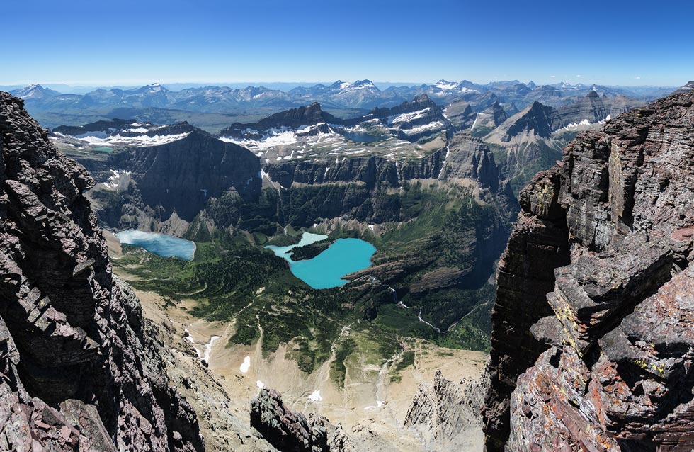
We planned to take one of the drainages or ridges up to the saddle - whichever seemed easier at the time. We started up onto one of the ridges but the drainage looked cleaner and easier, so Chris traversed over to it on a big ledge. Just when he got there we heard crashing from above and some rocks came down. Chris ran while a head sized rock bounced off the ledge 30 feet above him and sailed over his head. Welcome to Mt Merritt. That shook us a bit. We went a bit higher on the ridge and then quickly crossed the drainage to the next ridge over and headed up that. We were glad to see occasional cairns here, but not so glad to deal with a fair number of loose and shifting rocks. We slowly worked our way up weaving through cliff bands and up to the saddle. There we saw a grizzly and cub in the distance heading towards the base of Natoas Peak. We were hoping to climb this peak later as from this angle it looked like something Dr Seuss might draw. We tried to see where the bears went, but lost them in the shade of the N side (we think). Then we headed up towards the summit of Merritt. We didn't expect this to take that long, but it sure did. The ridge itself had some cliffs on it, so we were traversing along the S side above the Old Sun Glacier following ledges and goat trails. There was a mountain goat that we saw ahead that went to the saddle S of Merritt. It seemed pretty unconcerned about us and just watched us slowly mover along. We tried to go up where we could and eventually ended up below a snowfield. I am a bit more comfortable on snow and went up to a thin section of the snow where I was able to kick steps up to the rocks above. Chris made an end run to the east and traversed back above it. Then we traversed over to a notch in between the NE and SW summits and headed to the SW summit first. This one probably isn't the highest point - and in a few years definitely won't be as the rock seemed much more prone to falling down on the thin ridge. It did have spectacular views though, especially down to the west where multicolored lakes and waterfalls were below peaks and glaciers. The air was pretty clear today too, so the views were that much better. We visited a few points along the ridge before heading back to the NE summit - probably higher and a much more solid pyramid of rock. This summit also had a register. We signed in and took some more pics and then headed down. There was a mountain goat (maybe the one we had seen earlier?) on the ridge and it dropped down below us and then circled around above us as we followed the ridge down and then dropped onto the S side. By the time we got back to the saddle it was much later than we expected to get there (about 4:30) and we reluctantly decided that it would be best to head down rather than try for more peaks. We could have done that but there were some bears we didn't quite know where they were and we figured that we would probably end up bushwhacking in the dark if we didn't head down now.
 |
|---|
We made better time going down than coming up although we did take turns moving through a few places where loose rocks were likely to get sent down by someone moving. Most of the time we were able to move in parallel down to the base of the cliffs. Unfortunately the scree/talus was mostly fairly consolidated so there would not be a glorious 1000 feet of scree skiing descent. Instead we picked our way carefully down with just a few happy feet of scree skiing now and then. We mostly were able to reverse our course down through the bushwhacking with the difference of it being easier to push downhill through alders but it was harder to follow the faint animal trails. We were quite happy to finally make it down to the trail and we were actually the first of the people to make it to camp that night. We lowered our packs, set up tents, and then I swam in the lake. That night we both had double dinners - I had 2 pots full of ramen with lots of additions (dehydrated potato, veggies, peanuts, etc). I was actually quite full by the time I finished. Other groups had made it to camp by then including a group of women who were planning on climbing Merritt the next day. We went to bed pretty early as usual.
8-2-2024 another early start had us hiking up the trail in the dark. Soon we had passed the turnoff we used the day before and were in new territory. We passed a campground and then started uphill to get past a waterfall - things were getting light now too making it easier to take pics and pick berries. We also had nice views of Pyramid Peak as we hiked past it. Above the waterfall we went by a lake and then up past some more waterfalls. As we went across the next plateau we stopped to fill up with water before heading up the hill to Stoney Indian Pass. There we left the trail and headed up the slope working our way through the cliff bands before cutting onto the west side to follow a long sidehill ledge heading north. Eventually we climbed up and over the ridge to a saddle where we took a break before following an even longer and mostly thinner ledge on the east side traversing below the Stoney Indian Peaks. For the most part it was easy walking with a few spots where the footing wasn't so solid or the rock pushed you out off the trail. Eventually we worked our way to the end of this traverse and then headed up the slope towards the final summit plateau of Mount Cleveland. There was a final basalt looking cliff band and then we were on the plateau. We could see a grizzly with 2 cubs in the distance heading away and west and a solitary larger grizzly that seemed indifferent to our presence. We went a bit closer and it gradually ambled up the slope and around the corner onto a snowfield, but in no way seemed to be particularly moving away from us as most of the other bears had. We slowed down considerably and then worked our way up on the opposite side of the broad summit ridge and to the summit. It was a bit hazier this day, but we could see down into Canada and over many of the other peaks we had climbed in Glacier. At 10,466 feet Mt Cleveland is the tallest peak in the park and it also has 5,226 feet of prominence, making it one of the "ultras", as well as being a national park high point etc. This was the last of the 10,000 ft peaks in the park for Chris, but I still had one to go. We took pics and ate a bit.
The descent went slowly at first as we were unsure of the big bear's location. We gave it's last know spot a wide berth and worked our way down. Once below the basalt cliff band we went faster down to the next saddle. I was in a bit of a zone walking the eastern traverse and had a rare chance to rest in the shade and wait for Chris to catch up. Then we did the western traverse and worked our way down through the cliffs and back to Stoney Indian Pass. Then we just had to walk back on the trail with photographic opportunities and berries to distract me. We opted not to try to swim in the lake we passed and instead went back to camp and swam in the lake there.
That night we finished off most of our food and went to bed fairly early - but not before seeing some of the people who had tried to climb Merritt but backed off after it took them until much later than they planned to get up to the saddle. It looked like weather was supposed to come in the next night, so if I wanted to complete the last 10,000 ft peak in the park I needed to do it after hiking out. We planned on another early morning to get out with enough time to complete this last peak.
8-3-2024 We got up early and packed up and headed out. With our slightly lighter packs plus generally downhill travel we made good time and soon stopped to get water as we passed the Gable Creek campground. Then we continued back towards the trailhead. Here we could hear faint howling ahead and left of us probably wolves down along the Belly River somewhere. A little later we heard them again - behind and left of our position. That was cool. I managed to keep up with Chris most of the way, but lost him as we headed uphill to the trailhead. He stopped to wait for me and I was able to barely keep up the last mile or so to the trailhead. There we parted ways - he was going to meet his parents at the airport and then they would take his Jeep and he would fly home to work. I had a date with Mount Siyeh.
The weather was not looking particularly good as I drove south and back into the park - in fact there were a few bits of rain along the way. Not at all the clear until 10pm forecast I was expecting. Sigh. The parking area was pretty crowded, but there was one space just a few cars away from the trailhead. I worked my way into the tight parallel space and prepared for the hike. Mind you I was pretty tired from days of peaks not to mention the 13 miles with an overnight pack that morning. I packed up my stuff being sure to pack my raincoat and headlamp and then drank a Monster energy drink and headed off. At first I was moving pretty slowly, but gradually I got up to at least my normal pace if not one that Chris would have set. The part up the trail was pretty uneventful and I passed enough people heading the other way that I wasn't too concerned about bears. Then it was time to head cross country towards the peak. There was a pretty obvious use trail (actually more than one, but I took the one that was part of most of the tracks I had). By now it was looking pretty threatening with occasional drizzle - but not enough to soak the rocks or me.
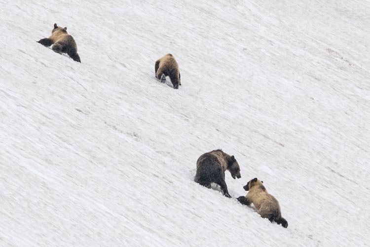
I tried to go fast, but that wasn't really in the cards (or my legs). Still, I made steady progress up and right towards the upper plateau. I heard a bunch of rockfall off to my left and saw some people coming down that way - fortunately I had traversed right so I wasn't below them anymore. It was definitely raining a bit and looked worse off in the distance as I got to the upper slopes (lower angle, but still plenty steep). As I got onto this slope I was able to see at least one bear far above me. As I got higher I was able to see more, 2 presumably younger adults off of their own above and to my right right of the snowfield, a mom and 3 cubs playing in the snow about where I wanted to go above me, and another adult off to the left on the ridge (as well as probably a different bear I had seen earlier up near the ridge right of the summit). The 4 in the snow gradually moved to the right and I worked my way left to get around them - they were still quite distant. I made my way up to the ridgeline and then headed uphill and downwind to the summit. The wind was blowing hard now, and carried quite a few raindrops. Not quite enough to make me wet, but the worst looked like it was still to come. I went up to the summit and tagged the possible high points and then crawled into a little sentry box in the rocks that was sheltered from the wind and the rain. There I put on my raincoat. I had made it to the 10,014 ft summit of Mount Siyeh - supposedly named after a crazy Blackfoot warrior who's nickname was Sai-yeh - meaning mad dog or crazy wolf. I did feel a bit like a mad dog up here with all these grizzlies and the weather. At least there wasn't any thunder or lighting.
 |
|---|
I zipped up my raincoat and headed down into the wind and rain. Almost immediately my legs were soaked. I also had to hold my hat brim to keep it from being plastered down over my eyes or flipping up and ripping off my head (and letting my glasses get soaked). As I headed down the ridge with one hand on my hat and the other holding my poles I looked to the side and way closer than I wanted to I saw a bear head pop up over the rocks (maybe 30-50 feet away). The bear looked surprised and stood up to get a better look. With the wind blowing sideways between us there was no way I could be identified by smell, but I did tell it I was just a friendly peakbagger heading downhill and I wasn't a threat. I continued down the ridge veering to the far side away from the bear. Once I was definitely past it I looked back more carefully and saw that it was one of the 2 that I had seen right of the snowfield earlier (they both were up on the ridge now, but also behind me and we were both moving away from each other). I hurried down the ridge into the wind until I got past the snow and then cut back towards where I came up. I was moving much more quickly downhill than I had up, but I was also soaked everywhere that my raincoat wasn't covering me and starting to get cold. I hurried downhill and onto the steeper slope below. There I followed my traverse below a cliff band stopping where an overhang provided shelter from the rain (and some of the wind). I stopped there to put on another layer below my raincoat. The added insulation along with less wind and also less rain (it was easing up a bit) helped me warm up. I mostly retraced my steps unless some other way looked easier. Back in the valley I made good time back to the trail and then headed down. The sun even came out a bit before I got back to the truck, but I was still pretty wet.
Back in my truck I put on some drier clothes and then headed back to the visitor center to get wifi and plot my return. I didn't really do a particularly good job of this and mostly just drove south until well after it got dark where I followed some signs for a national forest lake figuring I could sleep there. I don't know if I found that lake, but after far to long driving along dirt roads in the dark I did find a place by a lake to go to sleep.
I slept in a little the next morning (well, enough that it was light by the time I got up). Then I plotted a course south and drove on - at first on little dirt roads, but soon enough on paved ones and then the interstates. I made it into Nevada that day with a picnic dinner in Wells Nevada. I spent the night in a rest stop. The next day I drove through Ely and on back to Bishop, trying to fill up my tank as much as possible as the price of gas crept up. All in all a highly successful trip with mostly good weather and permit luck. Now I had a few days to rest up and get everything ready for the Sierra Challenge that would start in a few days. I had good fitness going into it - but also maybe not enough rest.
| |
|---|