Somehow I seem to have lost most of the photos I took over this time, so I guess this TR gets posted a little photo light. Probably better to at least post what I have.
For the long weekend we headed back out to the Joshua Tree area to meet up and do some peaks. We drove out Thursday afternoon with a stop along the way to hike up Olive Hill in Moreno Valley. This was a decent trail up to a peak with nice views of the snow-capped San Peaks. By the time we got to the meeting spot east of 29 palms it was dark, but we were still able to find enough wood to have a fire.
2024-01-12 Tom Becht joined us in the morning and we drove up the dirt road to somewhere near the wilderness boundary. There we left the Jeeps and started hiking - across the valley and down a wash to where we headed up another wash and then up a gully and ridge to the first peak - 2526. There were no reported ascents, but we found a cairn on top. Then we headed down across a valley and up the much higher Outlaw Benchmark - a 3291 foot p1K. Then we headed down the N ridge and across another valley and a small pass back to the Jeeps. On the way we saw the remains of at least 5 desert tortoises - pieces of the shells. On the drive back we put a heap of wood onto Tom's roof rack. We got back with plenty of daylight left to collect more wood before a warm rinse and first dinner. That night we had a big fire and second dinner.
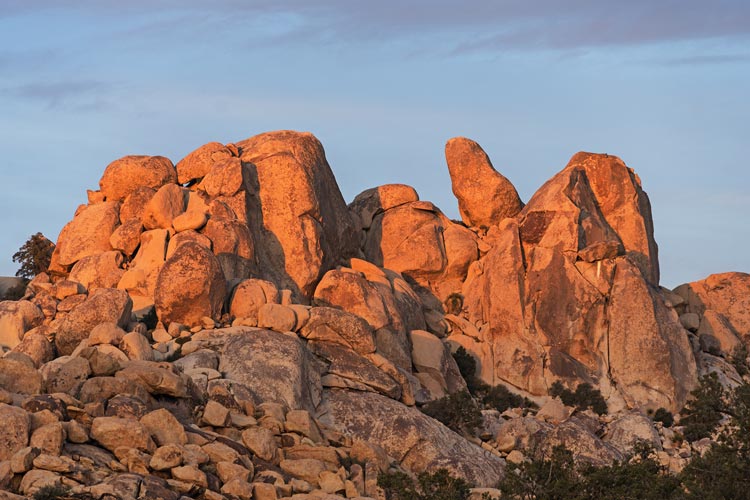
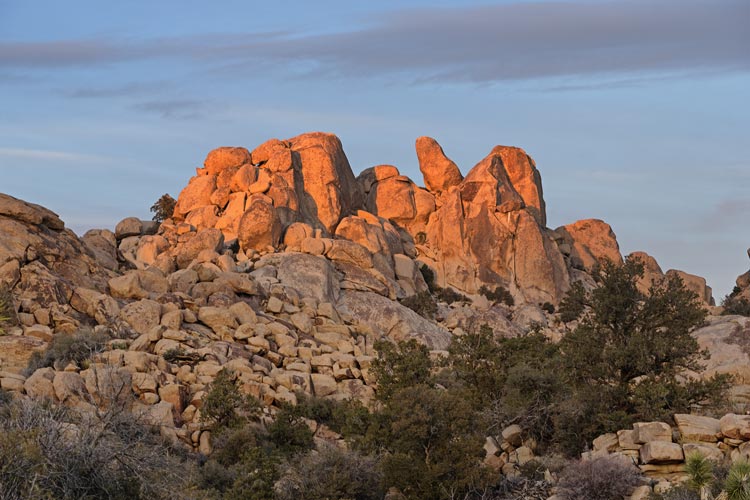
2024-01-13 We had a plan to go up some rock peaks in the northern Wonderland of Rocks in Joshua Tree NP. After a bit of research we realized that the climbing guides suggested hiking in from the S instead of the N, so we opted for that plan (and Tom had hiked a short way in from the N and said it was pretty rugged). We drove to the Boyscout trailhead and headed up the trail. There were some trail runners that left about the same time we did and we kept almost catching up to them all the way to Willow Hole. We also passed a surprising number of hikers. I guess it was a holiday Saturday on a popular trail. I had hiked some of this way in to do some climbs long ago, but didn't get all the way to Willow Hole. That was the end of the maintained trail and things got a lot slower. We worked our way E and a bit N to the NW side of Peak 4315. We scrambled up a steep notch to the shoulder on the W ridge, then we worked our way E on the N side before cutting back over the ridge. There it looked like a possible way up so I left my camera and pack and scrambled up - it went up and through a slot and then up a ramp and around to the top. There is something immensely satisfying about getting to the top of a peak when you don't know if it is possible. I returned and grabbed the short rope and a bit of gear to set up a handline if needed. It wasn't needed to go up, but we used it to rappel on part of the descent and then I untied it and downclimbed. It was solid 4th class if not a little low 5th with a very satisfactory summit block.
The descent was slow, but steady back to the wash, then we started scrambling up the next peak - 4497, also known as Super Dome. It took a lot of route finding and scrambling up over and under boulders to the NE shoulder. There was a possible route on the N, or around a little bit to the NW. I thought the N route looked a little easier and shorter, so we went back to that and I geared up. It wasn't very hard climbing - maybe 5.5 or 5.6, but the pro wasn't all that prolific. We had a 30M rope and a 60M skinny static rope. I led on the 30M and trailed the other rope. Iris followed on the 30M and Bob on the middle of the 60. After they got up Tom B came on the end of the 60M. Iris scrambled up to the summit while I was belaying and then I followed up. I saw a rap anchor on the S side, but we had left our packs and shoes on the N side. On the scramble back we saw a rap anchor on the NW side. Iris went down on a single strand of the 60 and got to a point she could scramble down from when she passed the half marker. Tom and Bob followed and then I doubled the rope and went down - scrambling the last 30 or so feet down. While I was pulling the rope Iris brought my pack and shoes down. After we packed up we started scrambling down the west side - route finding was tedious and circuitous but we made it down to the canyon bottom and then headed S back to the wash. It took a long time but we made it. From there we just had to hike out. Back on the trail we saw a number of people, many hiking in with overnight packs. The sunset was quite nice and I kept slowing down to take pics - and then hurrying to catch up. Meanwhile Tom jogged ahead. We got back to the parking lot just as it was getting dark enough to want headlamps. We were amazed at the string of vehicles heading west out of the park, fortunately we were heading east. It was cold and windy and our wash was pretty weak. Tom and Bob went into town to eat, and we cooked dinner and everyone went to bed pretty early.
| |
|---|
 |
|---|
 |
|---|
2024-01-14 We drove into the park and parked by the side of the road and headed across the desert towards the first objective - Peak 4330. This involved a pretty mellow hike across the desert with a few washes to contend with and then a big wash before the fairly steep climb up to the summit. It didn't really warm up until we started the uphill. From the top Bob offered to meet us at the Split Rock parking area, and we took him up on it - heading back down and then following a wash almost all the way. It had a few bits of prickly flora to contend with and a little dry fall plus some steeper jumbled boulders. All in all it was an enjoyable hike with the added bonus of passing some ruins and seeing an owl that flew away too quickly for me to deploy my camera and a dead tortoise shell. As we approached the Future Games Rock I saw Bob scrambling up the final bit to the summit that was marked "Split Rock" on List of John (LOJ). We detoured towards that pile of rocks and soon were scrambling up towards him. There was a steep arete/ridge to go up that was a little exciting and Tom B opted to continue on to the Jeep. The rest of us went up. Bob went back down the way he came up and Iris and I descended a dihedral for the upper part. Then Bob offered to drive the Jeep to the next trailhead and meet us on the next bump.
We were able to follow a decent trail from Split Rock about half the distance to the next peak, then we headed steeply uphill to the broad flat summit. It looked like a pyramid shaped rock to the east might actually be the high point. It was labeled 4733 on the topo map and the point we were at was called 4740 on Peakbagger, but that was just based on the contour interval. In any case once Bob got there we decided we needed to visit it, but first a rock just to the north that also might be higher - it was guarded by a moat, but appeared to be lower. The path to the saddle with peak 4733 was pretty steep, so we backtracked a bit and descended lower but more easily. Shortly after crossing the canyon bottom we came to a trail - that we could have followed from Split Rock. We followed this for a bit and then headed uphill towards 4733. Bob and Tom were ahead but I didn't see them on top - so it must not just be a walk up. As I got closer to the boulder jumble I could see a climb on one of them. I tried to go around CCW to the south but it looked taller and steeper so I went the other way around and under the boulders to the NE side. There I saw the other's stashed stuff and dropped my pack. Then I scrambled up around a vague circular path that took me higher until I was one rock short of the highest point. This was guarded by a 2 foot or so rounded gap with a significant drop. I was able to stem one foot across and then lean over and get my hands on top of the higher boulder and then mantle up onto it. From here it was an easy step across to the highest rock and scramble up top. When Bob heard I made it up he cursed at me, but soon he found his own way up by tunneling under the second highest rock and scrambling around on the SW side and then up. The others followed his path. Bob's gps suggested this point was 12 feet higher than the other one, my camera suggested it was slightly higher (using the built in level and the zoom). It would take better surveying than we were capable of to tell which is higher but the eastern one is a more deserving peak.
We headed on towards another peak to the north, quickly hitting a social trail, as we went past a large rock outcrop, I recognized it as an area I had climbed in the past - "Fraggle Rock" and so I looked for a cool dwelling built between and under some boulders and brought it to the other's attention. Then we continued north down the wash - not the easiest way to go, but more adventurous and it went past 2 mines that had been closed with welded barriers. We followed this drainage down and then crossed a big wash and headed up the other side to the summit of Peak 4822. By now the forecast high winds had arrived and distant visibility was poor and the wind was steady with very noticeable gusts - enough that it kept blowing my hat brim over my eyes.
We turned west and headed off for one more peak - one Iris and I had already done just over a year ago, Negro Hill. We dropped down the ridge past some old bedframes and other historic trash and then headed S a bit on an old road before turning west on another wash and then heading up the slope to the even windier 4875 ft Negro Hill. It was so gusty that Iris was blown off balance and hit herself in the head with the summit register. The descent was downwind and once we left the summit ridge the wind was less drastic. We headed back down to the Jeep and then headed out of the park, on the way we decided to tag a PeakBagger only peak "Junction Benchmark" just off the road. It was a short hike, but on the descent I had a cactus spine penetrate my shoe and stab me in the bottom of the foot. Evidently my hopping about was amusing. I was unable to pull the spine through, but I did break off the spine and remove the tip.
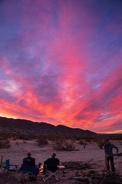
That evening the wind died down and we collected quite a pile of wood and had a nice fire. Tom B went home and the rest of us enjoyed the warmer evening.
 |
|---|
2024-01-15 The plan for today was to scramble and climb a heap of smaller named formations that were on Peakbagger and LoJ. Bob headed into town for his Starbucks fix and we met him at our first dot - Skull Rock. It was good to get to this one early as later in the day there are a lot of people there and scrambling up would not be low profile. I wore my Evolv Cruzers for the day - great for scrambling but comfortable enough for walking. Iris and Bob wore climbing shoes for much of the scrambling. Skull rock was pretty easy - maybe 4th class.
Next up was Jumbo Rocks - a high point east of the campground. We hiked from Skull Rock and found a way up from the NW. It looked like there would be a 5th class move near the top, but then we found that hiking around through a slot avoided it.
 |
|---|
We went to Horror Rock next, but Iris and I had already done S Horror Rock and both it and N Horror Rock (possibly not marked in the right place) looked like they would require a rope, so we skipped those and headed to Ryan CG. I was quite pleased to see nobody was on Headstone Rock, so we packed up some climbing gear and walked over. There were a few boulderers down below, but no climbers on it, so we scrambled up to the base where I was extra pleased to see a booty quickdraw hanging on the first bolt - winning. I headed up and then brought up Bob and Iris and we rapped back down. Then we walked to the Manure Pile - the rock formation in the center of Ryan CG. We scrambled up via a few different options on the N side and then headed down sort of the same direction.
We drove towards the intersection and parked off the side of the road and headed S to John Yablonski Rock - named after a climber. We should have gone a little up Keys View Road and parked in that parking area, but we didn't know. We scrambled up over boulders on the NE side and then cut S to the summit. The final block wasn't easily climbed, but the block just to its NW was more easily ascended. On top there were a number of bolts of various trustworthiness. We headed back down and then walked over to Cap Rock. It sounded like the easiest way up was a 5.2 crack on the NW corner. We headed up towards that and found a slab that went up under the cap. I made the move up that, but the others were more dubious, so we headed back to the vehicles for climbing gear. The crack looked pretty easy too, but I knew I could do the slab move, so I headed up that way. I belayed Bob up and then while belaying Iris up Bob scrambled on up under the cap and to the top. We followed up shortly. Iris was having fun dancing around on the summit cap. We rapped off on the N side with the 30M rope. In scrambling past the corner crack it did look like the easiest way up and down.
 |
|---|
We drove to the Hidden Valley CG area. First up Peewee Rock - we ended up walking all the way around it before scrambling up the S and SW side. This one is on LoJ but wasn't showing up on the Peakbagger app. It turns out the LoJ point was linked to a different point - Cinch BM nearby. Iris and I had already tagged that point.
After Peewee we went over to Chimney Rock, I had already been up this at least once rock climbing, but didn't know when. The chimney looked sort of hard at the bottom, so we opted for a different route up a chimney/ramp on the NW - N side I scrambled all the way up before returning to guide the others up. As we went up another climber started up with a rope to set a TR on "the flue" - a crack climb. We descended the same way and then headed over towards Outhouse Rock - there were a few other points in the area, but Iris and I had already done them, so we went to Outhouse Rock. The 5.4 chimney/slab climb looked a little too spicy for the others so we went back for the rope and a bit of gear. I led it and then brought up Bob and Iris. It was a little chilly up top in the wind, but the light was nice. There were plenty of people including boulderers and a few climbers visible from the top.
After Outhouse Rock we said goodbye to Bob who had a long drive home to the Bay Area. We stuck around a bit longer and tagged Trashcan Rock on the way out of the park bringing our total dots for the day up to 10.
It was interesting to be back at Joshua Tree after spending a lot of time there in the early 2000s. There were more people and vehicles than ever, but maybe less roped rock climbers (and more boulderers?). A little bushwhacking pretty much got you away from almost everyone, but the parking areas and trails were pretty busy. It is still a pretty magical place and we all agreed that it was a fun weekend.