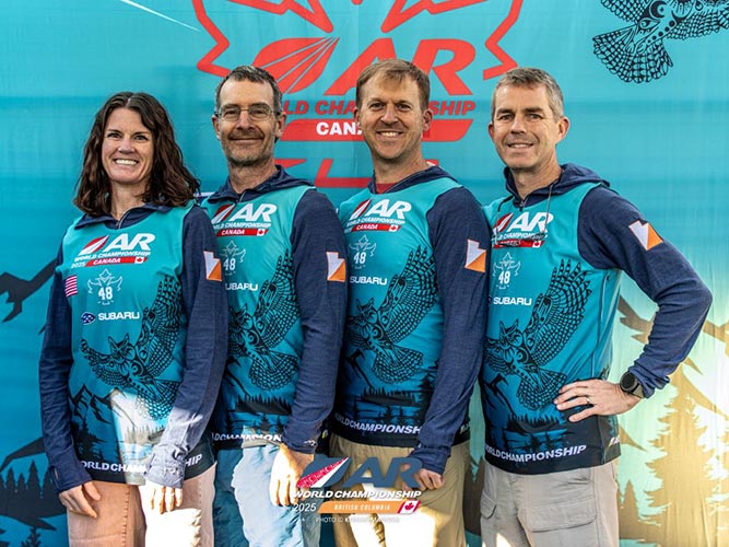
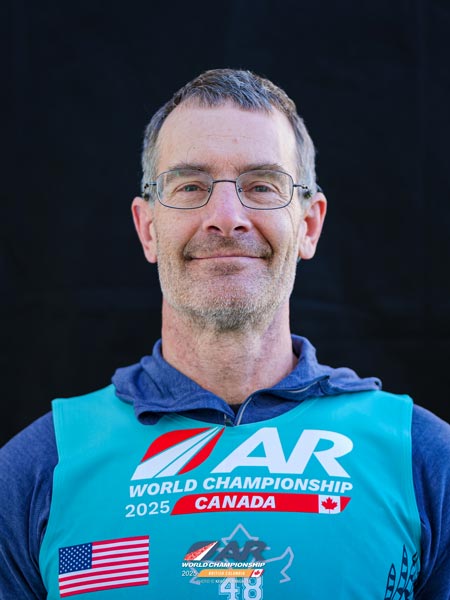
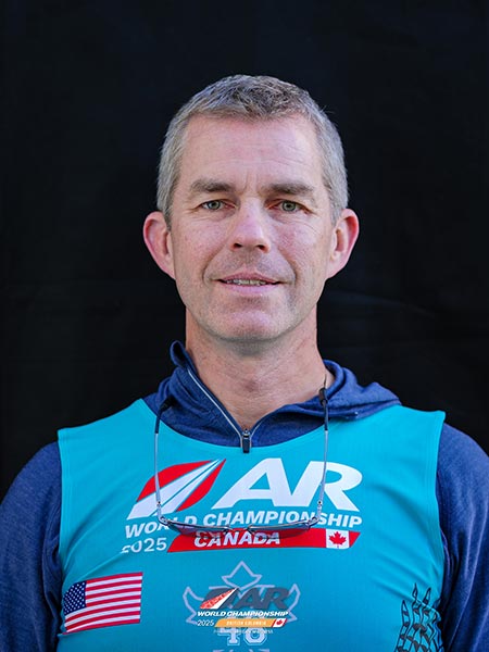
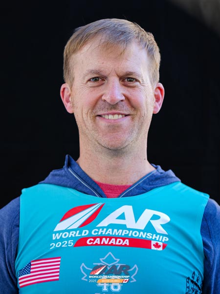
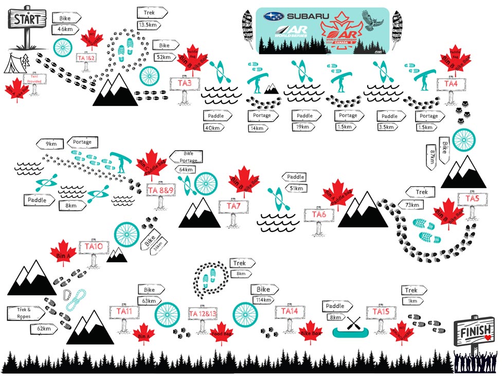
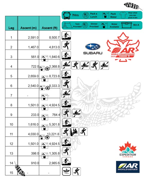
The 2025 Adventure Racing World Championships Expedition Canada. Based out of Penticton, we would be bused 7 hours from there to an unknown location and then spend the next 5-10 days getting back to Penticton via a combination of biking, walking, and paddling. I had about 3 weeks of notice before the race, so I was able to do a little bit of biking and paddling when the smoke wasn't too bad in preparation. Was it enough - I guess, was it ideal - no. As usual I was stepping in to replace someone that was unable to race, this time on team Orienteering Utah. This would be my first world championship and also the longest race I would be in (although the cut short 2013 Patagonia Expedition Race would have been close had we been able to finish).
| |
|---|
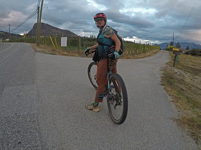
I started driving up Thursday Sept 18 and took part of 3 days to get up there, meeting up with Fletcher and Ian on the second day. Once in Penticton we messed with our bikes and tried to get all our food and gear in order. It seemed like a few days worth of messing with food, especially as I was making a number of sandwiches and wraps that I didn't want to do until the last day. There was a bit of a logistical maze trying to keep track of what gear and food needed to be in what bin and the bike box and paddle bags as well as keeping them all under weight. We also went for a brief mountain bike ride and scoped out where we thought the race might go from the Kettle Valley Rail trail to a beach (turns out we guessed this right, but still messed it up a bit in the event).
 |
|---|
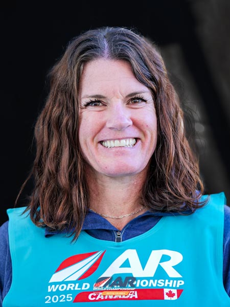
Sylvia was driving up to join us the 21st but after crossing the border her alternator went out (or else the pulley driving it) and she came to a stop. We drove down and loaded her gear into Fletcher's truck and get her truck to a repair shop (which was fortunately not far). More packing and planning ensued.
On the 22nd we had to do our skills test (flip the packrafts and get back into them in deep water) and then demonstrate the ability to clip into a via ferrata style of fixed ropes and then onto a rappel - plus the gear required for these activities. Then more worry about food and clothing and gear.
 |
|---|
 |
|---|
 |
|---|
 |
|---|
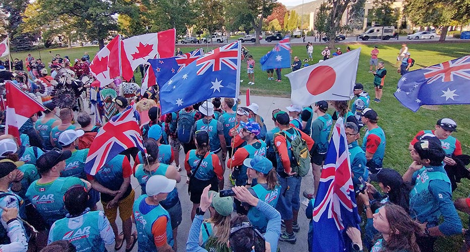
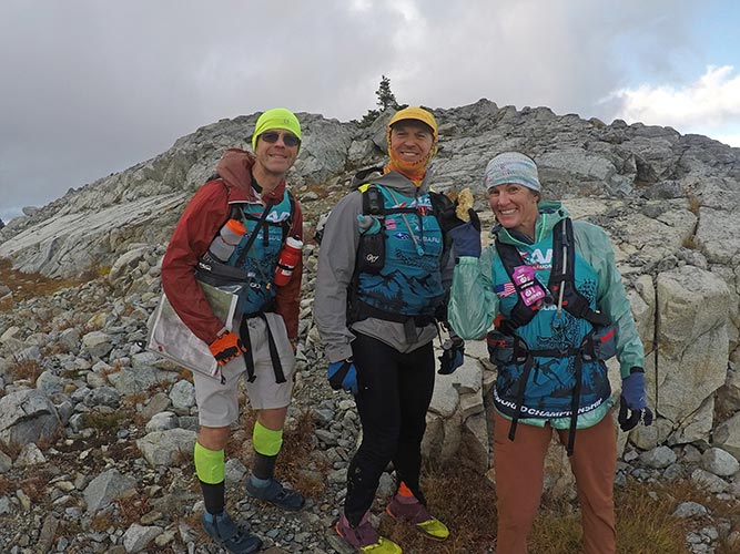
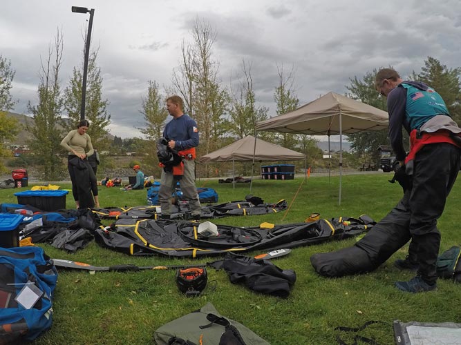
On the 23rd we had to show all our mandatory gear that hadn't been shown earlier (paddling and climbing gear). Then we had to head back and do the final packing of our bins and bike boxes and paddle bags and turn them in. One paddle bag was overweight so we had to shuffle things around a bit. Then that aspect was done, and other than bringing things with us there wasn't much we could do about it. That afternoon was the opening ceremony where we all walked in and we were welcomed by the local first nations leaders and dancers and singers. The animal spirit for this race was the owl - we were supposed to make wise choices like an owl - based on minimal information. We were also told that rather than wishing the race was easier we should wish that we were better, a sentiment that was warped and riffed on for the entire race - for example instead of wishing that it wasn't raining, wishing that we were water proof. That night we gooped up our feet and tried to get lots of sleep.
 |
|---|
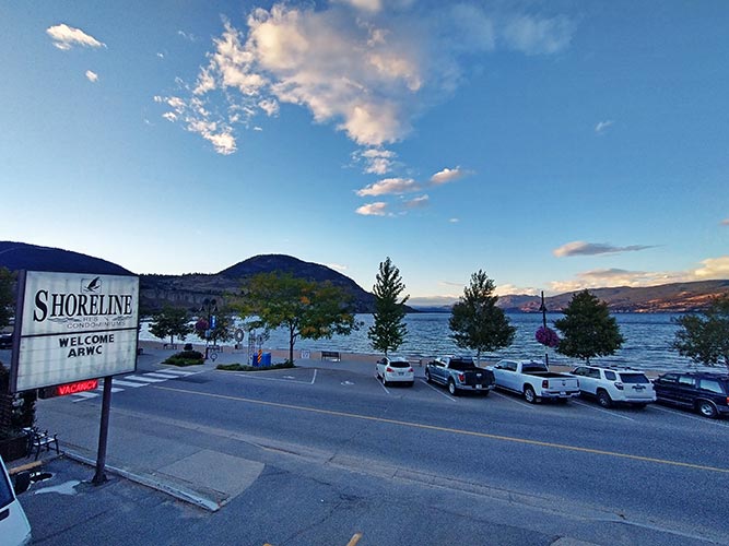
The 24th we got up early and took some stuff to be stored by the race, said goodby to our phones, and parked our vehicles on the street where there weren't any parking restrictions. Then we picked up our maps and race books (the first we got to see them) and filtered onto the buses for the drive to the start. We looked at the maps and race books on the bus trying not to get sick. Fortunately I had not plied myself with caffeinated beverages this morning so my bladder was not the one to nearly burst before we got to the first rest stop. We stopped again where there were a number of fast food options and then once more close to the final destination of Pemberton. We drove through Squamish on the way and it was interesting to see all of the development there since my last visit around 2005.
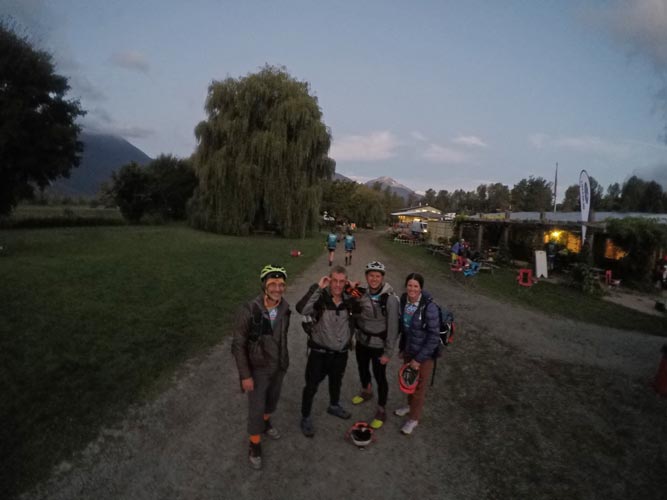
We stopped at the North Arm Farms where the race was to start. There we looked at the maps more, set up tents for the night, put together our bikes, and had dinner. There were some more opening ceremony events, and then we went to bed in the hope of getting a good amount of sleep for the last time in a while. Originally they said they were going to take away our bike boxes as soon as we assembled the bikes which would have meant that all the stuff we brought to sleep that night would have had to be carried with us or jammed into an already overloaded bin which we wouldn't see for a while. They relented and took the bike boxes in the morning which meant we could put some of the sleeping stuff into them. It was quite humid that night and the inside of our tents were dripping with water, but at least it wasn't too cold.
 |
|---|
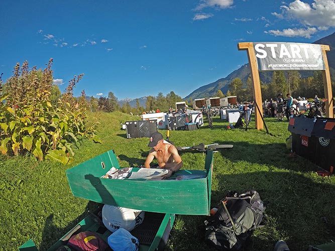
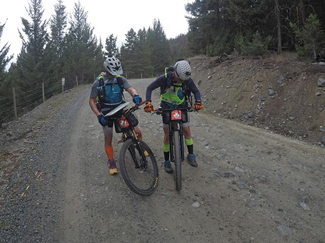
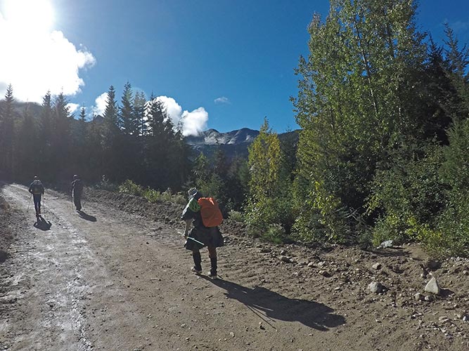
Thursday 2025-09-25 Race start day. We all got up before sunrise and prepared to start the race. This meant eating and waiting in line for the ~7 toilets for well over 200 racers that really wanted to clear the deck for action. Eventually we accomplished our business and packed up our tents, bins, and bike boxes and we were ready to start. We started off with a bit of farm exercise to separate the field a bit. First to a 1.2 km cornfield we had to run through and collect 4 ears of corn which we then shucked before running back to the bikes and starting off. Once on the bikes we were stopped at the road crossing until a break in the traffic which negated much of the separation from the first exercise. Then off to the start of the bike park where we could leave most of the non-biking gear. Fortunately we didn't go very far without the tracker so we didn't have to go back much to get it. Then we had a long steady climb up and up to the first CP (Checkpoint) and then up more before a long singletrack descent. We were able to ride most of the uphill, although it was easier to walk some of it and then for a while we were behind someone that stopped at the top of every switchback and steep hill and waited there until you had to stop on the steep part behind them before proceeding. It seemed that no matter how long you waited before starting up the hill, they always stayed in the way until you stopped.
 |
|---|
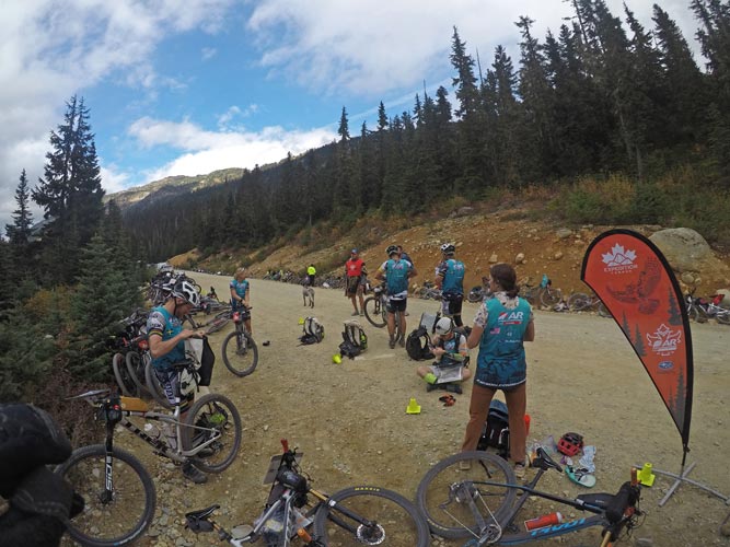
The descent started out on a blue trail which was mostly fun before proceeding onto a black diamond trail which was also mostly fun but had some steep drops that were better walked. It was somewhat difficult staying together and keeping track of the whole team as there were multiple teams going down at different paces through here and looking back without stopping was somewhat hazardous. We made it back down and then reloaded our stuff and set off on the bike path and then the road for a long ways. The road slowly gained elevation and then we went off onto a dirt road which headed uphill a lot. Hours of uphill. We were trying to go fast, but only had so much pep in our legs (at least I only had so much). Eventually we got up to the TA where the first team had just left, we didn't know which team they were (it was team 400 LSN), but soon after SAFAT came down and quickly transitioned onto their bikes. The next leg was a mountain trek and as we headed up the hill we passed most of the fast teams coming down the trail.
 |
|---|
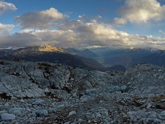
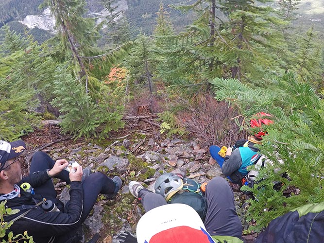
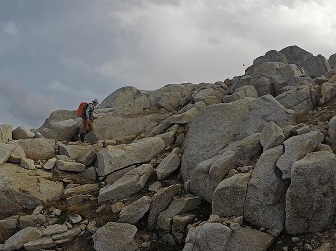
This mountain trek was pretty scenic, and it was nice to be more in my element. We collected the CPs heading higher into the mountains. From CP7 we headed up over the ridge and towards CP9 (CP 8 had been removed - it was on top of a mountain, the peakbagger in me was sad, but the slow adventure racer in me was glad not to have to head all the way up there). I'm not sure if this way to CP9 was easier or not - maybe easier travel but a little less direct. Sadly about here is where the evening rain started. At first it was just a sprinkle, but soon we were compelled to put on our raingear. It was getting dark after CP9 and the rain was picking up - fortunately the wind was mostly at our back as we headed up the slope to CP10-the last point on this trek. Then we headed down and back to our bikes.
 |
|---|
 |
|---|
 |
|---|
 |
|---|
By the time we got to the TA it was no longer raining and the road was mostly not wet. We started bombing down the road towards the next CP making pretty good time as we were mostly descending until Sylvia's front tire got a cm long rip in the sidewall. This was well beyond what the tubeless sealant could deal with, so we used an empty gu packet to cover the gash on the inside and put in an inner tube and pumped it up with a CO2 cartridge. It went flat. We put in another tube and that held and we headed on - for a while before it too went flat. Sadly at this point we were out of tubes. We worked on it some more and did find a thorn poking through that had pierced the tube. We tried to patch the tube, but it didn't work very well with so much goopy sealant everywhere. We were able to pump up the tire for a bit and go downhill until it went flat. For the uphills we walked. It was frustrating and we schemed ways to carry a bike and extra pack so the unbiked person could jog. Then another team caught up and we were able to get another tube (thank you Robotools Masters (I think)). We put that in and were back in business bombing down the hill to town and then on to TA3 at about 4:45 am on Friday the 26th.
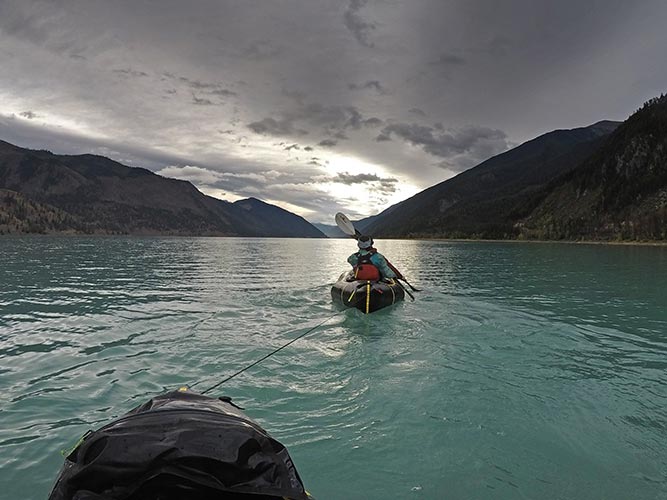
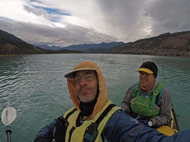
We should have just taken a short nap when we arrived, but instead we slowly put our bikes away and got the packrafts ready. We decided to wear raingear and not our drysuits - which most of the time we were very glad to do. It was getting light by the time we got out on the water of Carpenter Lake. Our plan was to tow the second boat and have one person in the rear boat take a nap. It wasn't the best sleep, but it was nice to close your eyes for a while. Along the way we saw a number of bald eagles either flying or on trees on the side. We were told not to stop to camp on the S side of the lake because of grizzly bears. At first there was little wind or even a slight tailwind, but this was a big long lake (40 km is a long way to paddle an inflatable) and after a few hours we started to get a headwind. Then it picked up. Eventually the wind got to the point that it was pushing the boats around and the gusts were whipping water into the air. This sucked. Fortunately that level of wind didn't last long and we were able to sometimes move in the lee of headlands. Still, it was pretty grim and one particularly strong gust from the side felt like it nearly flipped us over. We were all quite glad to get to the end despite the fact that my legs didn't really work and I fell over shortly after getting out of the boat. By the end we were questioning our raingear instead of drysuit decision. We packed the boat up and prepared for a pretty long portage (I brought my bigger old golight pack for carrying the boat - it had plenty of room, but wasn't the most comfy to carry).
 |
|---|
 |
|---|
This next portage went up over a mountain ridge from Carpenter Lake over Mission Pass and down to Seton Lake. At least it followed a road. Of course it was still quite windy and the evening rain came on shortly after sunset. We worked our way up over the pass and then what seemed like an endless descent down to Shalath where we sacked out on the ground for a few hours. Fortunately the rain had stopped. By now it was Saturday the 27th. We got up in the dark and set up for a paddle with our dry suits on. Then we paddled down Seton Lake to the end passing some blinking navigation markers arriving just as it was getting light and in time to paddle the whitewater as the dark zone ended at 7. We didn't deflate the boats, instead we had 3 people carrying the front end of the boats where the gear was stored and one in the back. This worked out pretty well and soon enough we were past the dam and putting in for the first whitewater section. The crux of putting in was dodging the dead and rotting salmon on the shore. I also saw some barely alive salmon in the water.
This section of whitewater was pretty fun, I was in the back and the crux was mostly finding a passage that was deep enough. We grounded a few times but were able to bounce ourselves off and keep going. At the takeout we rolled up the boats and then walked to TA4 in Lillooet. Our goal was to complete the transition in time to make the 10 am departure for the noon-1 opening of the road. (just before the race started they learned that the road was going to be closed for rock clearing during the day, which threw a wrench into some race timing, but worked out ok for us). We managed to build our bikes and pack up the paddle gear and depart at the 10:00 window. We biked out of town and made it to the road closure with about 30 minutes before it opened - time enough for a bit of a snack and a nap.
At noon they let the cars go through one way, then the other, and then let all the racers through. Shortly after we were through the road work we teamed up with the Robotools Masters team somewhat informally, but with an 8 person semi-peloton we made better time than we would have individually. When we got off of the pavement we were moving more slowly and fell behind as we worked our way up into the mountains on dirt roads. The evening rain started a little before we got to CP20, and by the time we got there it was coming down in earnest. CP20 was an old emergency shelter hut, so we moved in to get out of the rain/wind and put on more layers. It was nice to get out of the rain and wind, but this place seemed like a prime hanta hotel with rodent droppings all over. Before we left 2 more teams showed up and it looked like they were going to start a fire in the stove.
 |
|---|
It wasn't quite dark when we started, but it wasn't long until it was fully dark as well as raining as we went up over the top of a hill and then started descending. Soon my tire got caught in a rut and I went down, fortunately not that fast, but it did get me more covered in mud and my chain kept coming off for a while. I also discovered that my rain pants weren't particularly waterproof. At least my top and core were mostly dry and not that cold. My hands and feet and legs were wet and cold though. It was also hard to see how deep the water in the ruts was. There was sleet mixed in with the rain. We dropped down a lot and eventually made our way to TA5 where we hoped to get good shelter. Sadly that was not to be. It was possible to get under an overhang and thus out of the rain, but all the truly sheltered spots to sleep were either taken already or off limits. We were able to warm up a bit with a propane firepit. I was pretty cold and in no condition to head off on a trek if it was going to keep raining (Which Ian wanted to do, and probably was the right move in hindsight since it stopped raining in a few hours). This was probably my physical low point on the race, mostly because I had been exposed to my kryptonite - cold water - for far too long. Instead of heading on, we searched for a place to get proper shelter, eventually setting up the tent under one of the canopy tents and getting some sleep in there.
It was definitely Sunday the 28th when we woke up and slowly got going. First we had to try to clean the muck off our bikes and pack them up and then we were ready to go. It was starting to get light as we headed off. At least it was no longer raining and things were only damp instead of sopping wet. It was also nice that we were walking on dirrt roads instead of through wet plants. We walked through ranch land and forest. On the way we passed a team of 2 that had managed to get up to about 1800 meters or so in the rain and snow with heavy wind the night before and then spent a pretty miserably night trying to sleep under a tree before bailing back in the morning. Fortunately it was not raining and there was even some sun as we worked our way up to the very windy summit of Cornwall Hills where there was an old fire lookout that provided shelter for a foot-care break. Before we left team Crossfit Fort Vancouver showed up. We ended up walking with them for the next few hours to CP22 where Robotools showed up and then headed towards CP23 with 3 teams before breaking up and heading our own ways after that.
 |
|---|
We followed a logging road up towards a ridge top and then an old logging road (not on the map) heading in the direction we wanted to go. Sadly it turned nearly 90 degrees and we followed it for a while hoping it would turn the way we wanted to go. We gave up and headed back and took a semi-path down through the woods. There wasn't much of a trail, but a combination of clearings and animal trails mostly took us in the direction we wanted to go. We had some slight confusion about the exact direction we wanted to go - partly due to declination issues, but in general we were just heading downhill - a lot. As we got closer to treeline we could see a few lights down below and guessed about which ones were along the road we wanted to get to. Eventually we made it down to the road and passed CP25 on the way to CP24.
At CP24 they took our dysfunctional tracker (it had us at 0,0 in the Atlantic off the coast of Sierra Leone). They charged it up and reset it. I hoped those following us weren't too worried about our dot issues. Our task here was to plant some willow trees along a creek for erosion control. This meant making holes and sticking pre-cut willow branches which had been dipped in honey into them and then tamping them all back. We were also able to get water here and do some foot work. There were some other teams here - both Crossfit and Robotools had beat us here by a little bit.
We then headed off back up the road past CP25 and on. The scale of the map through here didn't quite show all the roads and the instructions for CP26 involved going up a road that "looked like a driveway" in the community of Bonaparte. Trying to find a road that looked like a driveway in a native community with random dogs in the middle of the night was not my idea of a good plan. After wandering through some backyards following things that looked like driveways that were in fact driveways we ended up going up a road that led to a quarry. We saw other teams on the far side of a drainage up on the road there. We were able to find a way up an old road and then across the drainage on cattle trails up to the correct road which we followed to CP26. We could have cut cross country towards CP27 and probably would have during the day, but at night we figured it would be a better bet to return and follow the fenceline. We cut off down a ridge from the road and got back to where we had headed up - meeting a local person there who had led some of the other teams up to CP26 - that would have been handy.
We followed a bit of a trail along the fenceline (on the side away from the highway that was off-limit to travel here). One advantage of being near the back of the pack is that after a number of teams pass through they can beat a bit of a better trail. One of the media team pulled over on the side of the road and did a very mini interview across the fence as we went by (asking who were we and how were things going). It took longer than we expected with more up and down to get close to CP27, but we made it. After that we went up to the road and crossed it and then went to CP27 at a Taco Stand and store - closed for the night. After that we were just walking along the road for a shockingly long distance. First through Cache Creek and then as it got light down the hill and over a bridge into Ashcroft. It was Monday the 29th by now. We had hoped to get here while it was still dark to sleep, but that was not to be.
 |
|---|
 |
|---|
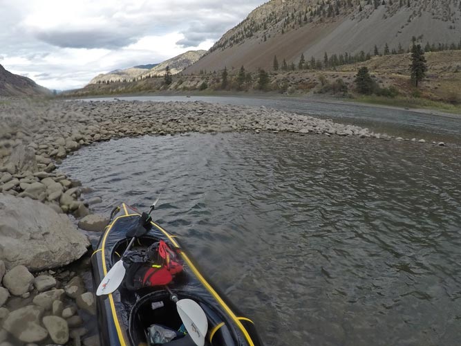
We inflated our rafts and put on dry suits for a long paddle down the Thompson River. I was paddling in the back of the raft with Sylvia for this stretch. This was a 51 km paddle on a big river at relatively low water levels. The waves would be big, but there wouldn't be a whole lot of rocks to dodge. The other worry would be getting stranded by a shallow gravel bar. We started off with a number of pretty big wave trains which were more fun than difficult in our double rafts. The other raft did hit a hole hiding in the wave train but they punched right through it. There were pretty busy railroad tracks on one or both sides of the river through this canyon with mostly freight trains heading quickly downhill or more slowly uphill. The complication we didn't know about would be a strong upstream wind blowing us sideways into places we didn't want to go and obscuring the signs of what was going on underwater - were all those little riffle waves from a shallow gravel bar or just the wind making little whitecaps? This wind made the paddle a lot less casual and fun than it might have been, but the fast downstream current made it go pretty quickly even with the headwind. Sometimes we were barely moving faster than the water, but that was still pretty fast. We stopped once to dump out water and then again to add more air to our raft that was getting a bit floppy. In the middle of a rapid a particularly strong gust pushed us sideways into an eddy-boil that nearly flipped us and then near the end we went though a rather large set of waves that had a sideways component that got a little exciting. Fortunately we managed to stay upright. We also saw an osprey dive into the river and come up with a pretty big fish (salmon?) that it flew around with for a while before dropping it back into the river. After the takeout we carried the rafts up from the shore and to the access road where we packed them into our packs and rebuilt and cleaned off our bikes for the next leg. I also realized that the sole on one of my shoes was starting to get worn to the point there were holes through it into the foam below, so I switched to my spare shoes - from Nnormal Tomir to Nnormal Kjerag - a lighter more precise shoe, but also a little tighter on my toes and less padding underfoot.
 |
|---|
 |
|---|
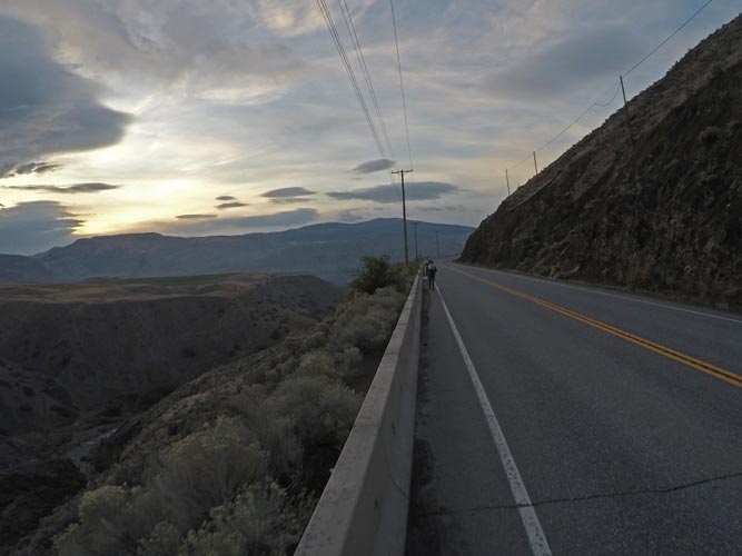
Leg 8 was a bike portage - a fancy way of saying we had to bicycle 64 km with 1500M of elevation gain while carrying our boats and boating gear as well as the usual mandatory gear and any other gear we might have with us. That meant our packs would be a lot heavier and consequently our butts would be hurting even more. I was also feeling a bit like I was coming down with something here. My throat and sinuses didn't feel so good and I wasn't doing very well thermoregulating. I think I was wearing my long sleeves and puffy jacket while Fletcher (who did run warmer) was in a t-shirt. It was getting dark as we left TA7 and headed south on Trans Canada Highway 1. As you can imagine this was a road with a fair bit of traffic, fortunately it also had a decent shoulder most of the time. We had reflective vests over our packs and blinking back lights as well as plenty of white light out front. Still, the massive trucks barreling past were a bit unnerving. Things got more exciting with some construction zones that narrowed things down to a single lane and sometimes erased the shoulder. Since construction was stopped for the evening we were able to cross the barriers and ride on the closed lane for some of the time, but when we were forced onto the single travel lane we waited for a gap and then tried to ride as fast as we could (uphill) so the vehicles behind us weren't slowed for long. It was pretty sketchy. We caught up with another team in this area.
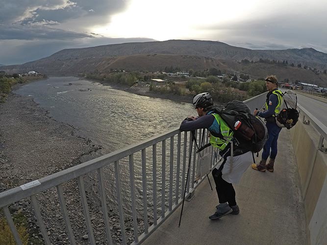
As we got to the town of Lytton the evening rain started to pick up to the point we needed to get our raingear on and we fell behind the other group. We were unable to take the obvious route down into Lytton as it was fenced off for construction. Instead we continued uphill on the main road before cutting back downhill into town and CP28 and a footbridge over the Fraser River. The rain was picking up and I was pretty sick of it and also feeling a bit sick. On the other side we poked around taking various routes that looked promising at first but then headed the wrong way or turned out to be a driveway or just looked very untraveled. I was pretty sick of the rain and being cold and so on, probably my lowest point of the race mentally. We gave up trying to find the way and just took a few hours nap on the porch of an abandoned (looking) house. At least we were dry if not warm.
It was definitely the next day (Tuesday the 30th) when we got up and after poking a little farther up some of the trails we tried before our sleep we found what looked like the right route. The rain was easing up, I had more layers on, and we seemed to be making progress again, I wouldn't say I felt good about things, but I felt better. Our next obstacle was a washout where a drainage had washed away the road. Fortunately it was easy enough to walk our bikes down and across the creek and up the other side. In the hour before the sun came up I was feeling quite tired and having a hard time staying awake. At least we were going uphill on a road so my somewhat weaving and erratic path wasn't very dangerous. We walked the steeper parts and I was a bit more alert as it started to get light before we headed downhill. The impending dawn brought a bit of a second wind - and the generally downhill travel was easier too. There was a bit of confusion looking for the final drive down to TA8, but we checked down the road a bit and found a sign that clarified things. We rolled into TA8 in the morning which meant we didn't have to worry about the dark zone (which they had already said we could have avoided by walking up and down with our boats).
At TA8 we learned that they had closed the paddling section because the safety boaters didn't think it was safe. Our quick view of the Nahatlatch River on our drive down made it look pretty scary, so we were mostly more relieved than disappointed. We slept a bit before taking as much weight out of our paddling gear as we could (keeping all the mandatory gear, but not taking the sprayskirts or drybags that we would have used for paddling). Then we headed up the road on foot.
 |
|---|
Despite the fact (or maybe because of it?) that this was a completely useless thing to do - carry our boats up to the put in and then back - it actually was one of the more enjoyable legs of the race. It wasn't raining anymore and was in fact almost sunny and we joked and laughed as we walked up the road - and also looked at the rapids to our left that looked pretty continuous and scary. Any little bit looked paddle-able, but if you swam, it would be a long and painful swim. If we were going to paddle these I would be trying to scout lines and remember them which would have been an impossible task. We came up with new flavors and marketing schemes for 4 hour fuel, silly new product lines, and product reviews. We punched CP29 and took a brief break and look at the river and then headed back to TA8 (which was now TA9).
 |
|---|
Back at TA9 we packed up the boats and tried to plan what gear we should have for the next few legs and where we could put things for later - basically at this point if we didn't have it in a bin we would see later we wouldn't get it until pretty much the end of the race and would have to carry it with us if we wanted it. We biked off down the road enjoying some nice smooth pavement. We crossed the Fraser River into Boston Bar where we saw Rocky Mountain AR and then a little farther south on the highway before turning off and up a dirt road. A lot of the start of this road was pretty steep, and we walked it. this allowed Rocky Mountain AR to pass us again. I was frustrated because some of what we were walking was road that seemed pretty rideable to me. Most of my frustration was because it started to rain again. Sylvia figured out how to put the pack over the handlebars to get it off your back, but it made steering harder, and more annoying to my mind at the time it made it more trouble to get onto the bike to ride. Eventually the grade eased and we started riding more - and the rain picked up. By the time we got to TA10 it was raining for real. We planned to get a nap sitting by the fire there, but Crossfit Fort Vancouver and then Robotools showed up and we were talking instead of napping. It was a pain trying to sort gear and food in the rain that was picking up. We were able to do a bit under the awning shelters, but couldn't really expand into the staff area. At least I had my better raincoat and rainskirt here. We also got information about the next leg - it was a long one and Alex gave us times we would have to make to avoid taking a short course (and where that was) and we also learned that with the new rain they were closing the ropes section, one of the parts that I was looking forward to. Instead of following fixed ropes and then rappelling down to CP34, we would have to backtrack and then bushwhack to the bottom of the rap to get there. That would be the final decision point for if we would continue to try to clear the course or take a short course option. We still hoped to be able to clear the course, but realized it would be better to short course here rather than miss a TA cutoff.
We headed off after midnight - so now Wednesday the 1st. We walked up the road in the rain looking for a sheltered place to take a short break. I found a decent sized culvert that was dry and we crawled in there for a short nap (15 min I think). Then back out into the rain and on up the road. In hindsight we probably should have had a longer sleep there, but we wanted to get farther up the road. We walked on for quite a while and finally gave up on finding another sheletered spot and stopped to set up the tent for a longer sleep. That was slow and a pain in the rain, but once we did it the sleep was pretty good.
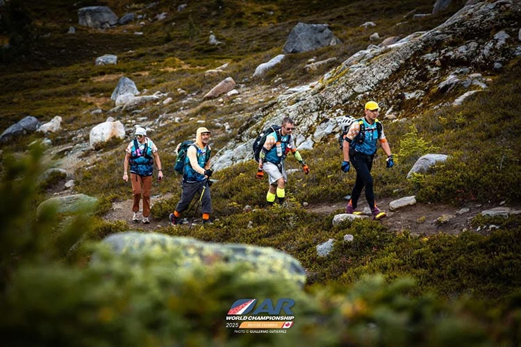
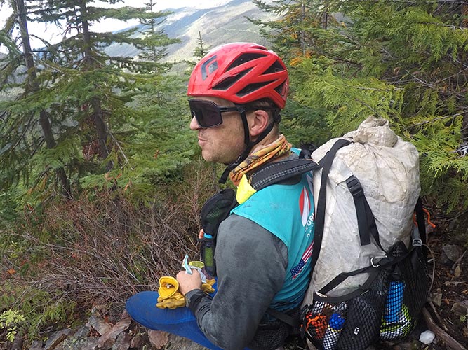
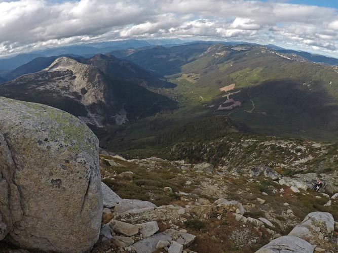
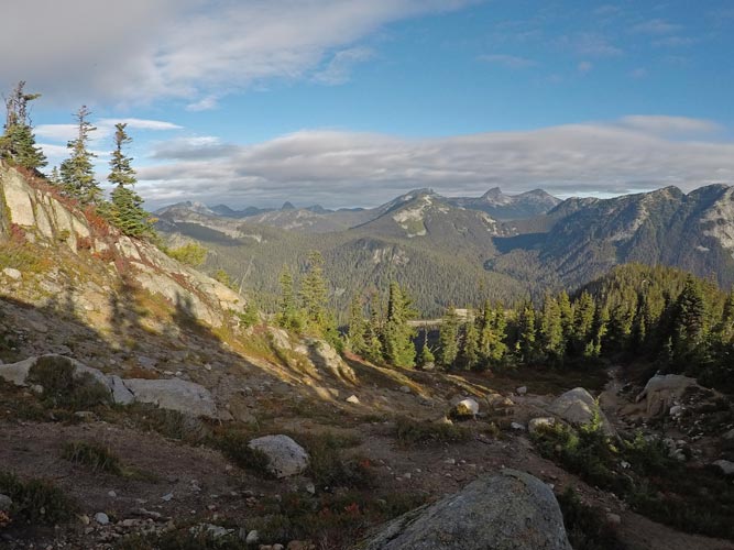
We got up in the morning as it was getting light. Of couse just a few hundred yards up the road there was a big double culvert that would have saved us quite a bit of time as well as being drier than the tent option. It might have been colder though. Oh well. On up the road to CP30 where the remains of Rocky Mountain AR caught up with us. Here we got water at a creek before the bushwhacking up into the mountains started. We cut a bit to the south on an old (but alder covered) logging road before turning and heading more directly up the slope. This section was described as a "very difficult bushwhack", and while certainly not easy going, it really didn't reach the level of a "very difficult bushwhack" in my mind. None of the plants were particularly hostile - like poison oak, nettles, or thorns, and while there were plenty of downed trees and it was steep, you could usually find a path around the thickest plants and downed branches. There were bad sections with soaking plants, but mostly it was just slow. At least I felt like we were making decent progress. We were in fact making progress and eventually we got up near treeline and CP31 where we were able to mostly follow a flagged route up to the 6978 ft summit of Guanaco Peak and CP32. By now it was partly cloudy and the views were most excellent. Also excellent were the blueberries.
 |
|---|
 |
|---|
 |
|---|
 |
|---|
 |
|---|
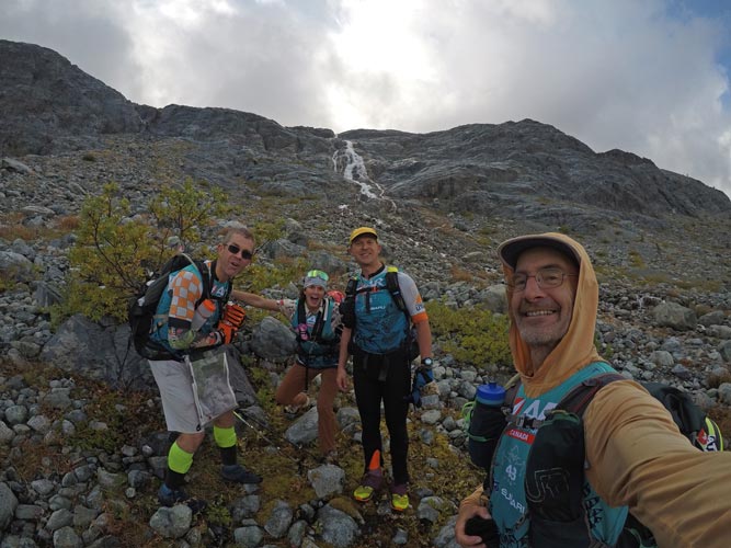
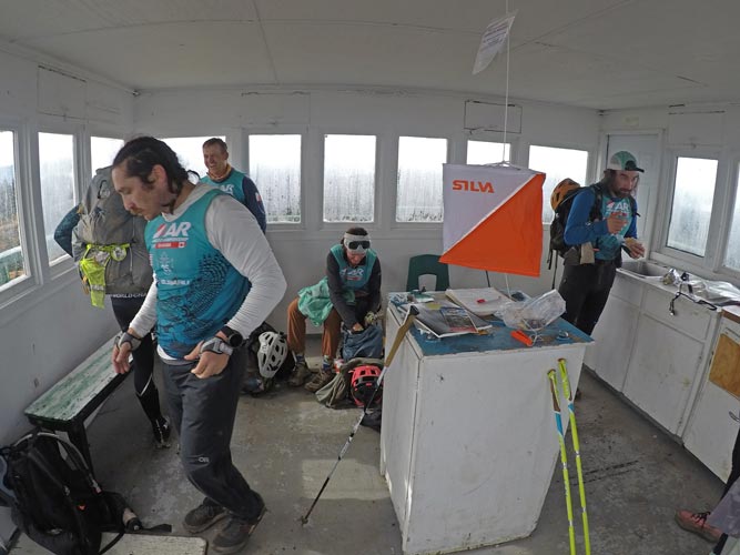
After Guanaco Peak there was a bit of a use trail down towards the saddle to Vicuna Peak (which looked really cool, but sadly was not on the itinerary). Then we dropped off to the NE and then over to CP33 and what would have been the start of the ropes section. We punched this CP and then backtracked to the use trail down for a little bit before bushwhacking over towards CP34. This took a bit of searching about to find, but we didn't actually take much time finding it compared to some of the teams that spent hours searching for the CP (I thought - where would a race director end a rappel?). This was the decision point - short course our team or forge ahead to try to clear the course. It turns out we were unanimous and unambiguous in our decision to continue. After CP34 we headed South bushwhacking down and across the slope towards the talus - treeline edge and the shoulder around to take us towards Llama Peak. We weren't allowed to head up the slope here and take the ridge over, which probably would have been quicker, but was deemed too risky. So down down down bushwhacking through the woods and brush before we got to the talus. This was much easier travel, but didn't last long before we had some more bushwhacking through another stripe of plants and then to the base of the slope. We followed this (there was even a bit of a trail here) on to where the angle was lower and headed up the slabs towards Llama. Once we got above the slabs the going was easier, except it got dark and it started raining again. At least my top was going to stay dry, as well as above my knees. We worked our way up the plant covered slope trying to dodge the sections with thicker brush and trees. As we neared the top of the slope we ran into a cliff, fortunately we were able to cut left and follow some ramps up to the ridge top. Here we cut right to get to Llama and CP35. This was a mistake as it was actually pretty close to our left. We went almost all the way to Alpaca Peak before realizing and turning back. Fortunately by now it had stopped raining and there were stars above. Sylvia asked about the light in the sky, and it was the Northern Lights - looking like a glow rising up from the northern horizon. The peakbagger in me was disappointed to not go all the way up to the summit of Alpaca Peak. We also met up with Crossfit Vancouver again here. We headed back down the wide ridge to the saddle and then up to Llama and CP35. Next up was another peak farther down the ridge. A lot farther than seemed right as we searched a number of other summits along the way without finding CP36. As usual during an adventure race the lesson learned in Expedition Oregon - especially at night - is that it is farther than you think. We eventually made it up to the summit of Zupjok Peak (Zupjok is the offspring of a cattle bull and a nak - or female yak). It was getting pretty cold by now, but since it wasn't raining and I was mostly dry and had decent gloves I wasn't actually cold as long as we were moving. After this peak the trail got a bit better as it headed downhill towards the Zopkios rest area along the Coquihalla Highway. We headed downhill and passed a nice shelter just before the highway - that was full of at least one team sleeping. As we got to the parking lot by the highway we saw Alex's van with a note saying to wake him up - although I think he just slid the door open as we approached. Not only did he congratulate us on our passage of that section and have advice for the next section - mostly just remember the bushwhacking was only 3.5 km, but he had hot dogs for us and said we should sleep in the family bathroom at the rest stop. Say no more. We headed over to the rest stop bathroom and moved in to the family bathroom which was heated and had a door we could close. We didn't figure out how to turn off the lights, but that was no deterrent to our sleeping at this stage of the race.
We got up and were ready to go as it got light outside on Thursday Oct 2nd- well before the food truck opened for business though. Between the hot dogs and a warm dry place to sleep and a truck parked in front of the food truck and general tiredness we (I) didn't punch CP37 located at the food truck. Fortunately I realized this before we had gone very far up the trail on the other side of the road and we were able to return and punch it and then get back to where I realized the oversight in 30 minutes. We continued up the trail gaining a lot of elevation up to the ridge which we followed across a saddle and up to a small lake where CP38 was. We saw a school group there who had also seen a number of other teams go through while they were camped in the area. The teacher seemed much more interested and impressed by the race than the students.
 |
|---|
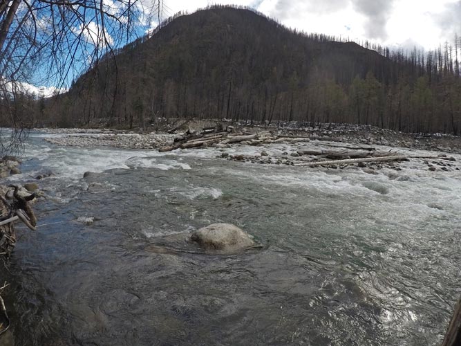
From CP 38 we headed east southeast down towards the Coquihalla river along the drainage of Needle Creek. Sometimes the travel was pretty easy, but in the creek bed it was very slippery and we all fell down at least once. On the sides of the creek sometimes we were just walking down through the woods, but more often it was choked with alders and then lower alders plus devils club - an evil plant that I had been injured by in the PNW before. Fortunately we were mostly able to avoid it or push it aside. Wearing leather gloves helped. Even more fortunately we were near the back of the pack so at least 100 people had already come through this way. Usually following their "elephant track" was the easiest way to make progress. Sometimes it probably led us astray though. We went down and down with one reprieve to walk down through a short-lived section of open mossy forest on the right bank before returning to the alders and devils club. Then we hit a waterfall and cut off to the left onto steep forested terrain. This was much faster going, although it was a little scary as we were descending and side-hilling a steep slippery slope with what looked like a cliff below us. Once again there was a pretty obvious trail where it was steep. The trail was harder to follow in a less steep section, but we picked it up again as we came out of the Needle Creek drainage into the larger Coquihalla Canyon. The last descent to the old KVR (Kettle Valley Railroad) grade was very steep and we half slid, half ran down the last part of that onto the grade. That offered a short reprieve before we continued down to the river and saw the bridge over it - which looked like a bit of work to actually get to walk across, instead we just hopped across on rocks and then to the road. We stopped to recover our sanity and work on our feet. I dunked mine in the creek for some nice relief. We were getting ready to go when Crossfit Vancouver came down the slope and up to the bridge.
We were happy to walk up the road for a while - so much easier than steep bushwhacking. It got old after a while though. The map just had a road going up the SE side of the river, in reality the road crossed and went up on the NW side (they said take a pipeline road which did stay on the SE side. We missed that detail until we got farther up and were committed to that side). Fortunately we saw a way to get where we needed to go without having to go back or walk along the forbidden highway. This worked out ok and we made it to TA11 before it got dark. Here we were transitioning to our bikes when much to our surprise - especially Sylvia's, her parents showed up. They were relatively close on their roadtrip to Penticton and realized we were almost to TA11, so they headed there too. I almost left my puffy jacket here, but last minute decided to stuff it in my bag - a smart move. I also ate a bunch of food before we left.
It was pretty much dark when we left. We were a bit confused about directions to pass through barriers blocking the road at one turn - it turns out the usual night time adventure race caveat applied - it was farther than we thought. We had to walk our bikes past a washout, but mostly we were just riding along a dirt road gaining and then losing a lot of elevation down into the town of Tulameen and CP39. Then we took a short break in the public restroom out of the cold and then headed on - in a bit of a fog. We blew the next turn seeing it, but it didn't look like we imagined from the map, and we thought it was a bit farther - turns out this time we were wrong. We went quite a bit too far and realized that we had definitely overshot all the way to some road (I can't find the name now). We should have just taken that road up and back to where we needed to go, but weren't sure that was allowed so we headed back and started up the road where the map suggested to go. We were frustrated at losing the time so powered up the road instead of carefully looking for the trail marked on the map that wasn't actually the road. We had gone up a lot before it was obvious that we weren't on the trail. The potential road marked on the map dead-ended up above, so we weren't sure what to do. We were looking at a side-road when we saw lights coming down it - turns out it was Crossfit Vancouver. They had headed up it and decided it wasn't the way. They headed back down, we continued up the main road since it was going the direction we needed to go and the map had it going to within a few hundred feet of gain from the road above. It turns out it went all the way up and then with a little jog to the left we continued up a steeper road/trail that took us up to the China Ridge trail system. There we saw a few much better signs and a warming hut (with a team in it). With the useful maps we were able to easily navigate to CP40 at another hut (despite some confusing beta from another racer who was trying to be helpful). Then once again with the better maps it was pretty easy to head down the ridge to TA12. It also helped that it was now light on Friday the 3rd.
We rolled into TA12 and Ian got the maps for the orienteering course and worked on them while the rest of us prepared to walk a bit and also tried to get ready for the long bike ride after. I also tried to get some electronics charging - bike blinky lights and my watch. Then we headed off to do the orienteering or O course. Since I had the race passport to punch at each CP I tried to make sure I was in the lead when we got to the CP. That didn't always work, but I actually had a decent amount of energy, so it mostly did.
Frustration was running high - the maps were just blown up regular maps - no extra detail, something like a 40 M contour interval - so what looked like a flat plateau on the map was actually cut by 2 50 foot deep brush choked gullies - making the planning not particularly useful and navigation a pain. Also we were trying to go fast - and not doing a good job of communicating. It all came to a head - words were exchanged, maps were thrown, it wasn't good. We took a deep breath and picked up the pieces and got the last 2 points. The fact is we had all put too much into this to quit now, so we swallowed our pride and anger and did what we had to to finish the race - work together.
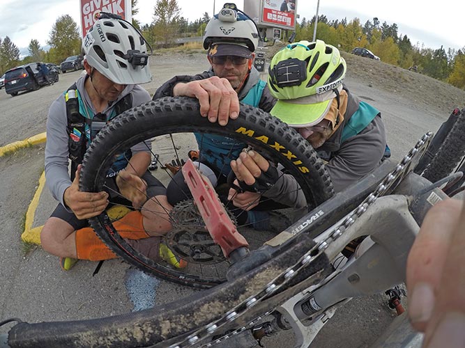
Back at the TA we got some of the leftover volunteer food (there was more than they could deal with as the race slowly closed behind us and supplies got moved to the last TAs). Maple cookies are yummy. The wind blew my bike over (leaning against a fence) and the headlamp mount re-broke. Fortunately we wouldn't be riding singletrack in the dark anymore we hoped and I had a decent headlamp and the 18650 batteries from the bike light would work in the headlamp. We packed up our bikes for a long ride and headed off down the singletrack towards Princeton. Things were going well until Fletcher got a flat - a hole through the sidewall big enough that the sealant wasn't sealing it. We tried to patch it with a bacon strip, but it was old and not particularly sticky and we didn't have glue for it. It didn't seal. So out came an inner tube. We felt for thorns hiding in the tire this time - a mess with the sealant - and inflated the tube with a CO2 cartridge - it inflated and then went flat. I have come to the conclusion that at least the CO2 inflater we had is pretty useless for anything but tubeless tires. We tried to patch the tube and put a boot in the tire as some teams went down past us but had limited luck. We got enough air to stay in the tube to walk the rougher singletrack and then ride down to Princeton where we searched for a bike shop with no luck. We did find some nice locals who helped out though. We put more air in the tire, but that popped the patch I think. Next plan was to try to reseal the tubeless tire. We tried that for a while at the gas station with limited luck - that failed shortly after. We had one more tube now given to us, so we went to a tire store to use their air pump. There we were regaled with tales of UFOs and Candle People (who were getting on the UFOs) while we worked on the tire. Eventually we got the tube in and we were back in business heading off towards the KVR trail (Kettle Valley Railroad).
 |
|---|
We worked various schemes of drafting, towing, and a 4 bike train towing, and so on to work our way up the gradual grade of the old Kettle Valley railroad as the light faded from the sky. Once it got fully dark we did less towing as it was harder to work together with the limited visibility. We pushed the pace pretty well on the uphill so that we would be ok with our time cutoffs. It looked like as long as we kept it together we were in decent shape. When we started falling asleep we decided that one longish sleep made more sense - take 2 hours from moving and sleep for 1.5 hours was better than say taking 3 half hour naps but taking nearly 3 hours of not moving to do so. So when we found a good flat spot we stopped and slept for real.
It was painful getting back up and we actually just walked the bikes for a few minutes to warm up and get our joints and minds moving before we started riding. Then we were able to push on through the night with only a few 5 minute micro naps. I remember for one of those Fletcher just sort of came to a stop and fell over and started sleeping. He claimed this was on purpose. The KVR track was usually wide enough to ride 2 wide so we tried to do that and keep talking to stay awake. We went through a small town where we passed one of the race media people - it felt like we were actually getting somewhere. As we headed downhill our speed picked up and it got colder. We also had some trouble finding CP49 Which was overlooking the dam of a lake. We had been keeping track of our mileage with the one remaining functional odometer and it seemed we had overshot. Another time where the usual rule did apply even though our mileage was accurate - we just didn't take into account all the little wiggles in our real track so we still needed to go farther. Eventually we found the CP and we were back on our way. The trail continued downhill as it got closer to Penticton and we went along Trout Creek for a while and then started passing more and more signs of civilization.
We went on roads for a little bit before returning to the KVR and finally to the part we had scoped out before the race. Of course in our sleep deprived and low visibility state we still turned early at one point and took a probably less direct route. Fortunately it didn't involve any big uphills or having to backtrack. Near the last downhill bits we passed Crossfit Vancouver heading back up the hill. They just said we'd see what the deal was when we got to the TA, but it obviously looked like biking to Penticton instead of taking the canoes. Sigh. We continued on to the TA where we were told that we had to bike to the finish line instead of canoeing there. I was pretty pissed - I was really tired of sitting on my bike seat at this point and was looking forward to canoeing as a change of pace. Also we had just come down a huge hill and I thought we would have to go back most of the way up this hill. ugh. I did dump some of my excess weight into my bike bag and grab some food to eat and grumble a lot. We later learned that Crossfit had just been told they would be short coursed - which they were obviously pretty upset about - as they had made all the time cutoffs (back of the pack teams have some pride too). It turns out the night before the wind and waves kicked up and they had the teams bike around - Cosmic Confusion was about 200 feet offshore and they were called to come back to shore and then re-build their bikes to bike around. There was almost no wind when we got there and the water was glassy and the sky was just starting to get light - near perfect for a paddle.
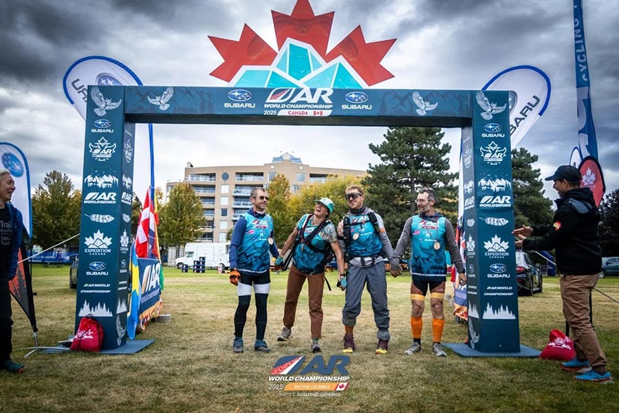
We headed back the way we came and grumbled our way back up the hill - although we didn't have to go up nearly as far as I feared. Then we got back on the KVR and headed south above the lake until we were even with Penticton and headed down a long curved road into town and then north along the river to the last CP at the SS Sicamous. There was an AR meeting going on there and the participants came out and cheered us on - and posted a video online - a definite surprise. Then we biked up the waterfront - were handed US flags, and pedaled through the finish arch. We dropped our bikes and returned to the arch for more pics. Bend Racing and Eastwind were there along with Alex, one of the race designers, which was nice. We had joked about the arch being already taken down. Then they had us take our finish photos and there was a cool down spot with some food and a propane fire pit.
 |
|---|
 |
|---|
 |
|---|
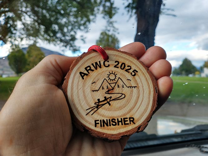
We were the last team to finish in 217:20:45 (over 9 days) - the lantern rouge team. (compare to SAFAT finishing in 116:06:30 a full 100 hours faster) I'm not sure when the course closed, maybe 220 hours. Finishing last doesn't mean that we were the worst team - there were other teams that dropped out for various reasons - usually injury of a team member, or who were short coursed for various reasons - usually because they didn't make a time cutoff or they were afraid they were going to miss one. So as best I can calculate we came in 37th out of 54 teams. We also counted as a "masters" team - meaning our combined ages was over 192 I think (I definitely helped push us over that). I don't know how we placed among this category though. This is the first adventure race I have actually cleared, so that was gratifying. Usually we have had to skip at least one CP because of time constraints.
.jpg) |
|---|
.jpg) |
|---|
.jpg) |
|---|
.jpg) |
|---|
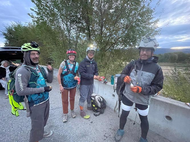
Then we got our stuff together in a pile and I headed to get my truck to put things away. Back at my truck I called Iris and was talking to her when it started raining. uh oh. I headed back to get things before they got soaked. Fortunately most of my things had been thrown in a waterproof race bin. I separated out dry and wet and nasty things with an eye towards drying out what needed to dry in my front seat. I didn't do a particularly good job of grabbing gear international or other people flying were abandoning, but I did get a small pile of butane/propane canisters. After loading my truck I went up to the hotel room and passed out on the floor for a while.
I didn't sleep particularly long before heading back out to the closing barbeque. I was hoping that there was some sort of buffet as I was getting ravenous but sadly there was just a meal from the food truck - it was good, but I could have probably eaten 3 or 4. I talked to people for a bit and then was joined by Ian and Fletcher, by now the food was running out, so probably best that I hit it early. We watched some of the closing ceremony, but when they started in on hall of fame nominees I was fading. We went back to the hotel to crash. The after party might have been fun to check out, but I was done. Fortunately I remembered and was able to motivate to move my truck to free and legal parking for the night. Much sleep was had.
The next day I slept in and then drank a lot of water as I was pretty dehydrated. Most of the day was spent looking at various bits of media posted by the race with a bit of time sorting, drying, and packing gear. I almost forgot to move my truck to overnight parking again before going to sleep for another well needed long rest.
Ian and Fletcher got up early to drive the whole way back to the Salt Lake City area. I slept in a bit and then packed up and headed south myself. The border crossing was a bit weird since I think I ended up going through the truck entrance (there was a stupid government shutdown and I think that was the only entrance open). It was a weird transition from pretty crowded on the Canadian side to near wilderness on the US side. I continued south making slow but steady progress on through the channeled scablands of Washington and into Oregon as a gorgeous full moon rose above the horizon. I stopped off a side road in the national forest in Oregon at a higher elevation to sleep.
I got up when I woke up and packed and continued south. I got a little worried I would run out of gas before I got to a station, but after a long remote stretch I made it to a much cheaper station in Nevada. My journey continued on through mostly empty Nevada to Highway 6 and back to Bishop where I unloaded the truck and separated out the dirtiest stuff and cooked dinner and went to bed. Over the next few days I did a lot of laundry, packed up race stuff, ate a frighteningly large amount, and slept and sat a lot. My garden had produced some truly giant zucchini - one was 11.6 lbs, but still fairly edible once I cut off the hard skin and scooped out the seeds and pulp. It took about 2 weeks before I started seriously thinking about doing much in the way of hiking or biking more than errands.
For food I had a mix of the usual prepackaged snacks like granola bars, pop tarts, and so on, a few gels with and without caffeine, a number of sandwiches and peanut butter and chocolate tortilla wraps I made ahead of time (mostly for the first few days). The other food we had was 4 hour fuel in a mix of flavors (simple drink mix with 4 hours worth of calories per serving) and some expedition mash - fortified mashed potatoes that could be eaten hot or cold (hot was better). Had I more time I could have done a better job of mixing and repacking flavors of 4 hour fuel so that they were in single water bottle portions - preferably slim enough to easily pour into the bottle. As it was for longer stretches I just had a single 12 hour bag which meant the same flavor the whole time. There were a mix of savory flavors like spicy ramen and pho and sweeter ones like berry and horchata. I think the latter might have been my favorite since the slightly gritty texture worked well with the flavor.
For gear I was racing on Ian's Norco Revolver hardtail mountain bike (he had a new full suspension one). Advantage - lighter than mine, probably more comfortable seat, dropper seatpost. I was able to stow it in my bike box once I removed one pedal and both wheels - much better than having to take off the handlebars. For most of the race I had shin guards on - I'm not sure how much they helped, but probably a bit, plus some insulation for the lower leg, especially as I wore capri length pants for most of the treks. I had 2 pairs of Nnormal shoes for the race, first a pair of Tomir that I had been abusing for a while. The sole eventually wore through - possibly partly due to sharp pedals. After that I switched to a pair of Kjerag at TA9 which were ok, but a little too thin in the sole and even less the shape of my foot. I think the Tomir were the right shoes, I just should have started with a fresher pair. The dyneema uppers gained very little water even when submerged and were very tough, the sole was pretty cush, although I did wear the tread out mostly before the race started. My rain pants were B-dry - and weren't dry enough, I think that was the piece I was most disappointed in. I had a Columbia out-dry top that was ok, and then switched to a more heavyweight gore-tex golite rain top which was even better and worth the weight. I took my old suffer suit montbell thermawrap top. It has a few holes but I was glad to have it along with a NWalpine hoody top and a thinner long sleeve sun hoody. The balaclava from the golite jacket was also a welcome addition and some gloves (I had a few pairs that I mixed it up with - leather for the long bushwhack, more insulated warm biking gloves that I wished I had earlier in the race, and a thinner pair of liner gloves as well as some rubber palmed work gloves and fingerless bike gloves. Also a pair of CWX compression tights and my bike shorts. They got swapped in and out as needed. I also had a number of pairs of darn tough socks, I think I mostly just wore 2 pairs though. For most of the race I used an Ultimate Direction 35L running pack, it worked well, for the sections where we had to carry the rafts and rafting gear I used a big golite pack - maybe a gust? It wasn't particularly comfortable, but it was light and packed small and was big enough to carry all the gear it had to. For rafts we had MRS barracuda 2-person rafts we rented. They worked well.
What I liked about the race - some good mountain biking, cool mountain treks including a few summits, point to point covered some serious distance, and the 2 whitewater sections we did were fun. What I didn't like so much - long grinding uphill bikes (mostly because I am bad at this), long treks on the road - mostly going into Ashton, long lake paddles into significant wind (once again would be less of a problem if I was better at this), rain most nights, not a lot of route choices - that might have been to our advantage or not. I didn't do a whole lot of the bigger navigation, which might have helped me keep my brain from getting used up and shutting down as often. There were only a few times where I felt I was really just falling asleep - less so than some other races I have been on. The lack of sleep still hurt, but I didn't feel crippled by it (much). Other than the first day and making the cutoff for the road construction we didn't feel like we had to push the pace faster, we just had to keep moving at the pace we were making which evidently I am pretty good at (obviously we would have had to go faster to place better in the race).
Lessons learned:
We probably should have brought Canadian cash (or widely accepted credit cards that didn't screw you on the exchange) and bought more food/drink along the way where available. Most of the best places we probably passed when they were closed, but we could have gotten real food and drink at a few stores and a bakery at a minimum.
I feel we lost at least 6 hours to problems with fixing bike flats - normally you just stick a tube in and pump it up and go. The re-flat from a thorn was the fault of not wanting to get intimate with the sealant to search for additional hazards (plus the sidewall rip was the obvious cause of failure), but it seemed to me that the CO2 inflation caused more problems than they solved. Maybe a fresher bacon strip plus glue would have allowed a quick and easy plug to fix the second flat tire. CO2 might be good for seating and reinflating tubeless tires, but just seemed to cause problems with tubes.
Obviously more training would be better, especially just "time in saddle" and long rides pushing the pace to prepare the behind for hours of biking.
Better rain pants would have helped. We were somewhat hindered in planning for weather because we didn't know where we were actually racing - I checked the Squamish and Penticton forecast and packed accordingly, but it rained more the first few days than I expected. Fortunately we were slow enough that we didn't actually get much freezing precipitation in the mountains and for the second and higher mountain trek we got rain on the uphill at the start of the night but it actually cleared up for the rest of the night and we were hiking when it was coldest (or in the heated bathroom sleeping).
I need to be more efficient at transitions - not that everyone was waiting on me, but if I was faster I could have helped more with group tasks and be more prepared myself for the next leg.
I am actually pretty strong and capable - I know this, but it is nice to actually experience it - there were times I was able to charge and push the pace, I am pretty good at finding a decent way through hard terrain - point me at a distant ridge and I can get there, my feet and everything else held up pretty well - sure I had a few hotspots and near blisters on my feet and hands, cracked lips, and painful places, but nothing that really went beyond annoying. Maybe that means I should have been shouldering more of the load and pushing the pace, or maybe it just means my body has done a lot of these things over the years and can handle it. There were times I felt like the weakest link, but it wasn't most of the time and even then I could keep going and didn't feel like I was slowing the group much.
 |
|---|
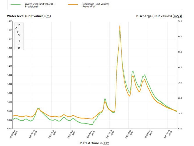
My Strava page for the race - 3 short zip lines where the watch battery ran out
I wrote a page of links before the race started, it might be mostly out of date, but you can find it here: pre-race page of ARWC 2025 links
I will include some of those links below as well as some post race video and other links.
AR world series page
Expedition Canada Page
Expedition Canada on Instagram (probably better access if you have an account)
Expedition Canada on Facebook (better access if you have an account)
Expedition Canada Youtube Channel has individual leg videos plus videos on communities the race passed
ARWS on Youtube
 |
|---|
 |
|---|